Greetings Card > Maps and Charts > Related Images
Greetings Card : Mars map 1895


![]()
Cards from Fine Art Storehouse
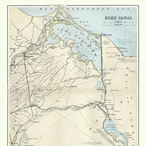
Mars map 1895
Meyers Konversations-Lexikon. Ein Nachschlagewerk des allgemeinen Wissens, 5th edition 17 volumes Bibliographisches Institut - Leipzig 1895-1897
Unleash your creativity and transform your space into a visual masterpiece!
THEPALMER
Media ID 18106747
© 2014 Roberto Adrian Photography
Greetings Card (7"x5")
Discover the captivating fusion of history and art with our unique Mars Map 1895 greeting cards from Media Storehouse's Fine Art Storehouse collection. This exquisite design features an intriguing image of Mars as depicted in the Meyers Konversations-Lexikon, 5th edition published by Bibliographisches Institut in 1895. The vintage map, titled "THEPALMER," adds a touch of nostalgia and wonder to any message. Perfect for space enthusiasts, history buffs, or anyone seeking a thoughtful and distinctive greeting card. Send a piece of the past to brighten someone's day!
Folded Greeting Cards (12.5x17.5 cm) have a laminate finish and are supplied with an envelope. The front and inside can be personalised with text in a selection of fonts, layouts and colours.
Greetings Cards suitable for Birthdays, Weddings, Anniversaries, Graduations, Thank You and much more
Estimated Product Size is 17.5cm x 12.5cm (6.9" x 4.9")
These are individually made so all sizes are approximate
Artwork printed orientated as per the preview above, with landscape (horizontal) or portrait (vertical) orientation to match the source image.
FEATURES IN THESE COLLECTIONS
> Fine Art Storehouse
> Map
> Historical Maps
> Maps and Charts
> Related Images
EDITORS COMMENTS
This print showcases a remarkable piece of history - the Mars map from 1895. Taken from the renowned Meyers Konversations-Lexikon, an encyclopedia that served as a comprehensive source of knowledge during its time, this particular edition was published between 1895 and 1897 by Bibliographisches Institut in Leipzig. The intricately detailed map offers us a glimpse into how our understanding of the Red Planet has evolved over the years. Created long before modern technology allowed us to explore Mars up close, it represents humanity's early attempts to unravel the mysteries of our neighboring planet. Every line and contour on this vintage map tells a story - each marking representing countless hours spent studying and documenting Mars' surface features. From sprawling canyons to vast plains, these visual representations ignite our curiosity about what lies beyond Earth's boundaries. As we gaze upon this print by THEPALMER, we are transported back in time to an era when space exploration was still in its infancy. It serves as a reminder of how far we have come since then and inspires us to continue pushing the boundaries of scientific discovery. Whether you're an astronomy enthusiast or simply appreciate historical artifacts, this mesmerizing print is sure to captivate your imagination and spark conversations about mankind's eternal fascination with outer space.
MADE IN AUSTRALIA
Safe Shipping with 30 Day Money Back Guarantee
FREE PERSONALISATION*
We are proud to offer a range of customisation features including Personalised Captions, Color Filters and Picture Zoom Tools
SECURE PAYMENTS
We happily accept a wide range of payment options so you can pay for the things you need in the way that is most convenient for you
* Options may vary by product and licensing agreement. Zoomed Pictures can be adjusted in the Cart.