Greetings Card > Granger Art on Demand > Maps
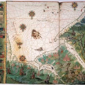
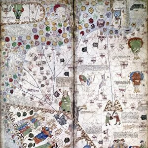
Greetings Card : MAP OF WEST AFRICA, c1547. From the Vallard Atlas; the map, drawn upside-down


![]()
Cards from Granger
MAP OF WEST AFRICA, c1547. From the Vallard Atlas; the map, drawn upside-down
MAP OF WEST AFRICA, c1547.
From the Vallard Atlas; the map, drawn upside-down as if viewed from Europe, depicts the trading fortress of Sao Jorge da Mina on the African Gold Coast
Granger holds millions of images spanning more than 25,000 years of world history, from before the Stone Age to the dawn of the Space Age
Media ID 12321008
1547 African Castle Fort Portolan Chart Topography Trading Post Elmina Gulf Of Guinea
Greetings Card (7"x5")
Step back in time with our unique and intriguing range of vintage greeting cards from Media Storehouse. This captivating design features a rare, upside-down map of West Africa from the Vallard Atlas, created around 1547. The map, which appears to be viewed from Europe, showcases the trading fortress of Sao Jorge da Mina on the African Gold Coast. Add a touch of history and mystery to your correspondence with this exquisite, artisan-printed card. Perfect for the history buff, world traveler, or anyone who appreciates the beauty of the past.
Folded Greeting Cards (12.5x17.5 cm) have a laminate finish and are supplied with an envelope. The front and inside can be personalised with text in a selection of fonts, layouts and colours.
Greetings Cards suitable for Birthdays, Weddings, Anniversaries, Graduations, Thank You and much more
Estimated Product Size is 12.5cm x 17.5cm (4.9" x 6.9")
These are individually made so all sizes are approximate
Artwork printed orientated as per the preview above, with landscape (horizontal) or portrait (vertical) orientation to match the source image.
EDITORS COMMENTS
This print showcases a remarkable piece of history - the Map of West Africa from 1547. Taken from the Vallard Atlas, this map is drawn upside-down, providing a unique perspective as if viewed from Europe. The focal point of this ancient cartographic masterpiece is the trading fortress of Sao Jorge da Mina on the African Gold Coast. Transporting us back to the Renaissance era, this map offers insights into the intricate topography and trade routes that shaped West Africa during that time. With its detailed depiction of rivers, ports, and fortresses, it provides a glimpse into the bustling activity along the Gulf of Guinea. One cannot help but marvel at Elmina Castle's grandeur in this image. Serving as a vital trading post for European merchants seeking gold and other valuable resources, it stands tall against an expansive backdrop. Its exterior exudes strength and resilience while hinting at centuries-old stories waiting to be discovered within its walls. As we explore this historical gem captured by 140_1653721, we are reminded of how art can transport us through time and space. This print serves as both a visual delight and an educational tool for those curious about Africa's rich past and its significant role in global trade during one of history's most transformative periods.
MADE IN AUSTRALIA
Safe Shipping with 30 Day Money Back Guarantee
FREE PERSONALISATION*
We are proud to offer a range of customisation features including Personalised Captions, Color Filters and Picture Zoom Tools
SECURE PAYMENTS
We happily accept a wide range of payment options so you can pay for the things you need in the way that is most convenient for you
* Options may vary by product and licensing agreement. Zoomed Pictures can be adjusted in the Cart.