Greetings Card > Granger Art on Demand > Maps
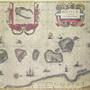
Greetings Card : MOLUCCAS: SPICE ISLANDS. Engraved map of the Moluccas or Spice Islands, from Jan Blaeus atlas of 1662


![]()
Cards from Granger
MOLUCCAS: SPICE ISLANDS. Engraved map of the Moluccas or Spice Islands, from Jan Blaeus atlas of 1662
Granger holds millions of images spanning more than 25,000 years of world history, from before the Stone Age to the dawn of the Space Age
Media ID 7515559
1662 Atlas Blaeu Dutch Indonesian Portolan Chart Spice Islands
Greetings Card (7"x5")
Add a touch of history and intrigue to your correspondence with our exquisite Moluccas: Spice Islands greeting cards. Featuring an engraved map of the Spice Islands from the Jan Blaeus atlas of 1662, these cards transport you back in time to the age of discovery. The detailed and beautifully preserved image of this important historical map, courtesy of The Granger Collection from Granger Art on Demand, makes each card a unique and thoughtful gift for history enthusiasts, travelers, or anyone with a love for the exotic. Write your message on the blank inside and let the allure of the Spice Islands speak for itself.
Folded Greeting Cards (12.5x17.5 cm) have a laminate finish and are supplied with an envelope. The front and inside can be personalised with text in a selection of fonts, layouts and colours.
Greetings Cards suitable for Birthdays, Weddings, Anniversaries, Graduations, Thank You and much more
Estimated Product Size is 12.5cm x 17.5cm (4.9" x 6.9")
These are individually made so all sizes are approximate
Artwork printed orientated as per the preview above, with landscape (horizontal) or portrait (vertical) orientation to match the source image.
EDITORS COMMENTS
This print showcases an engraved map of the Moluccas or Spice Islands, taken from Jan Blaeu's renowned atlas of 1662. The intricate details and craftsmanship of this Dutch engraving transport us back in time to a period when these islands held immense significance in global trade. The Moluccas, also known as the Spice Islands, were once considered the epicenter of the world's spice trade. This map offers a glimpse into their strategic location and natural resources that made them so sought after by explorers and traders alike. As we examine this piece closely, we can observe Indonesian rivers winding through lush landscapes, connecting various ports where ships would dock to load precious spices such as cloves, nutmeg, and mace onto their vessels. The portolan chart on this map provides navigational information for sailors venturing into these treacherous waters. Jan Blaeu's atlas was not only a cartographic masterpiece but also served as a valuable resource for seafarers during its time. It is fascinating to see how much knowledge was gathered about these remote islands centuries ago without modern technology at hand. Through this print from Granger Art on Demand, we are reminded of the historical importance of the Moluccas or Spice Islands and their impact on shaping our global economy today.
MADE IN AUSTRALIA
Safe Shipping with 30 Day Money Back Guarantee
FREE PERSONALISATION*
We are proud to offer a range of customisation features including Personalised Captions, Color Filters and Picture Zoom Tools
SECURE PAYMENTS
We happily accept a wide range of payment options so you can pay for the things you need in the way that is most convenient for you
* Options may vary by product and licensing agreement. Zoomed Pictures can be adjusted in the Cart.