Greetings Card > North America > Barbados > Maps
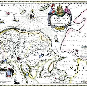
Greetings Card : Map of Barbados, c1764


![]()
Cards from Heritage Images
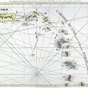
Map of Barbados, c1764
Heritage Images features heritage image collections
Media ID 14953436
© The Print Collector / Heritage-Images
Barbados Caribbean Cartography Colony Indies Island Map Making Print Collector21 Topographical Topography West Indian West Indies British Empire
Greetings Card (7"x5")
Add a touch of history and charm to your greetings with our exclusive range of Barbados Greeting Cards from Media Storehouse. Featuring an intricately detailed Map of Barbados, dating back to c1764, these cards transport you back in time. The antique map, sourced from Heritage Images, showcases the beautiful islands and its rich history, making for a unique and thoughtful gift for any occasion. Impress your loved ones with this piece of Barbados' fascinating past.
Folded Greeting Cards (12.5x17.5 cm) have a laminate finish and are supplied with an envelope. The front and inside can be personalised with text in a selection of fonts, layouts and colours.
Greetings Cards suitable for Birthdays, Weddings, Anniversaries, Graduations, Thank You and much more
Estimated Product Size is 17.5cm x 12.5cm (6.9" x 4.9")
These are individually made so all sizes are approximate
Artwork printed orientated as per the preview above, with landscape (horizontal) or portrait (vertical) orientation to match the source image.
FEATURES IN THESE COLLECTIONS
> Maps and Charts
> British Empire Maps
> Maps and Charts
> Related Images
> North America
> Barbados
> Maps
> North America
> Barbados
> Related Images
EDITORS COMMENTS
This print showcases a remarkable piece of history - the Map of Barbados from 1764. Created by an unknown cartographer, this map offers a fascinating glimpse into the British Empire's presence in the Caribbean during the 18th century. The vibrant colors and intricate details bring to life the topography and geographical features of this beautiful island. Barbados, a former colony under British rule, is depicted with precision and care on this map. Its strategic location in the West Indies made it an important hub for trade and commerce between Britain and its colonies in North America. The influence of France, another major power in the region at that time, can also be seen on this map. As we explore every corner of this historical artifact, we are transported back to a time when maps were meticulously crafted by hand. This print serves as a testament to both the artistry involved in map-making during that era and our human desire to understand our surroundings. The Map of Barbados from 1764 is not just an informative document; it is also a visual feast for those interested in colonial history or simply captivated by old-world charm. Whether you are studying cartography or have an affinity for all things British Empire-related, this print will undoubtedly spark your curiosity about Barbados' past while adding elegance to any space it adorns.
MADE IN AUSTRALIA
Safe Shipping with 30 Day Money Back Guarantee
FREE PERSONALISATION*
We are proud to offer a range of customisation features including Personalised Captions, Color Filters and Picture Zoom Tools
SECURE PAYMENTS
We happily accept a wide range of payment options so you can pay for the things you need in the way that is most convenient for you
* Options may vary by product and licensing agreement. Zoomed Pictures can be adjusted in the Cart.