Greetings Card > Arts > Artists > M > Gerardus Mercator
Greetings Card : Russia cum Confinijs. Map of Russia, ca 1595


![]()
Cards from Heritage Images
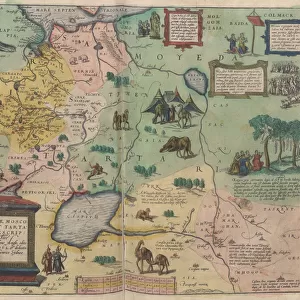
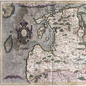
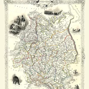
Russia cum Confinijs. Map of Russia, ca 1595
Russia cum Confinijs. Map of Russia, ca 1595. Private Collection
Heritage Images features heritage image collections
Media ID 15041462
© Fine Art Images
Cartography Early Rus Grand Duchy Of Moscow History Of Russia Mercator Moscow Principality Muscovy Russian History Copper Engraving
Greetings Card (7"x5")
Step back in time with our exquisite selection of vintage greeting cards from Media Storehouse. This particular design showcases a captivating map of Russia, dated back to approximately 1595, titled "Russia cum Confinijs." The intricate details of this map, sourced from a private collection and originally published by Heritage Images, will transport you back to an era of exploration and discovery. Perfect for history enthusiasts or anyone looking to add a touch of the old world to their correspondence, this unique greeting card is sure to leave a lasting impression. Order yours today and let the journey begin!
Folded Greeting Cards (12.5x17.5 cm) have a laminate finish and are supplied with an envelope. The front and inside can be personalised with text in a selection of fonts, layouts and colours.
Greetings Cards suitable for Birthdays, Weddings, Anniversaries, Graduations, Thank You and much more
Estimated Product Size is 12.5cm x 17.5cm (4.9" x 6.9")
These are individually made so all sizes are approximate
Artwork printed orientated as per the preview above, with landscape (horizontal) or portrait (vertical) orientation to match the source image.
FEATURES IN THESE COLLECTIONS
> Arts
> Artists
> M
> Gerardus Mercator
> Europe
> Germany
> Related Images
> Europe
> Russia
> Related Images
> Maps and Charts
> Early Maps
> Maps and Charts
> Gerardus Mercator's Cartographic
EDITORS COMMENTS
This print showcases a rare and historically significant map titled "Russia cum Confinijs. Map of Russia, ca 1595". The image, part of a private collection, takes us back to the Middle Ages when cartography was in its infancy. Created by Gerardus Mercator (1512-1594), a renowned Flemish cartographer, this copper engraving with watercolor detailing offers an exquisite glimpse into the early Rus and Muscovy. The map portrays the vast territory of Russia during that era, including the Moscow Principality and Grand Duchy of Moscow. It provides valuable insights into Russian history and serves as a testament to Mercator's mastery in capturing geographical details with precision. Displayed against a backdrop of fine art images, this print evokes curiosity about the political landscape and cultural heritage of medieval Russia. Its intricate design invites viewers to explore not only historical events but also appreciate the artistic intricacies involved in creating such maps centuries ago. As we gaze upon this remarkable piece, we are reminded that it is more than just an object; it represents our collective past and helps us understand how boundaries were defined during different periods. This photograph preserves an invaluable artifact for future generations while igniting our fascination for both geography and history alike.
MADE IN AUSTRALIA
Safe Shipping with 30 Day Money Back Guarantee
FREE PERSONALISATION*
We are proud to offer a range of customisation features including Personalised Captions, Color Filters and Picture Zoom Tools
SECURE PAYMENTS
We happily accept a wide range of payment options so you can pay for the things you need in the way that is most convenient for you
* Options may vary by product and licensing agreement. Zoomed Pictures can be adjusted in the Cart.