Greetings Card > Europe > United Kingdom > England > London > Sights > British Museum
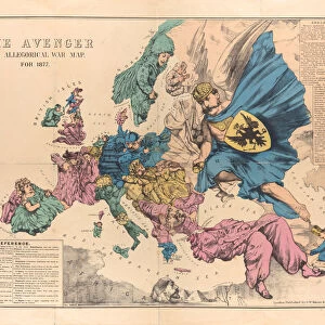
Greetings Card : Serio-Comic War Map For The Year 1877, 1877


![]()
Cards from Heritage Images
Serio-Comic War Map For The Year 1877, 1877
Serio-Comic War Map For The Year 1877, 1877. Found in the collection of State History Museum, Moscow
Heritage Images features heritage image collections
Media ID 15043436
© Fine Art Images
1877 1878 Balkan Balkan War Balkans Geopolitics Great Britain Ottoman Empire Ottomans Pan Slavism Panslavism Propaganda Russian Army Russian Troops Russo Turkish War Russo Turkish War 1877 1878 Colour Lithograph
Greetings Card (7"x5")
Introducing the Media Storehouse collection of unique and intriguing greeting cards, featuring the "Serio-Comic War Map For The Year 1877, 1877" from Heritage Images. This vintage war map, found in the esteemed collection of the State History Museum in Moscow, offers a humorous yet insightful look into the political climate of the late 19th century. With its detailed illustrations and clever commentary, this card is the perfect way to add a touch of history and humor to your correspondence. Whether you're celebrating a birthday, anniversary, or just sending a thoughtful note, our Media Storehouse greeting cards are sure to delight and impress.
Folded Greeting Cards (12.5x17.5 cm) have a laminate finish and are supplied with an envelope. The front and inside can be personalised with text in a selection of fonts, layouts and colours.
Greetings Cards suitable for Birthdays, Weddings, Anniversaries, Graduations, Thank You and much more
Estimated Product Size is 12.5cm x 17.5cm (4.9" x 6.9")
These are individually made so all sizes are approximate
Artwork printed orientated as per the preview above, with landscape (horizontal) or portrait (vertical) orientation to match the source image.
FEATURES IN THESE COLLECTIONS
> Arts
> Pop art
> Satire
> Satirical artwork
> Asia
> Turkey
> Related Images
> Europe
> Related Images
> Europe
> Russia
> Related Images
> Europe
> United Kingdom
> England
> London
> Sights
> British Museum
> Maps and Charts
> British Empire Maps
> Maps and Charts
> Related Images
EDITORS COMMENTS
This print showcases the "Serio-Comic War Map For The Year 1877" created in 1877. Housed in the esteemed State History Museum in Moscow, this fine piece of graphic art offers a fascinating glimpse into history and geopolitics. The map, a vibrant colour lithograph, humorously depicts the Russo-Turkish War of 1877-1878 with great attention to detail. It cleverly satirizes various European powers involved in the conflict, including Great Britain and the Ottoman Empire. Panslavism and Pan-Slavic sentiments are also prominently featured. Created by Frederick William Rose (1849-1915), this work is an excellent example of European satirical maps from that era. Its purpose was undoubtedly to serve as propaganda during a time when tensions were high between Russia and Turkey. Through its intricate illustrations, it provides valuable insight into the military strategies employed by both Russian troops and their adversaries during this significant historical event. As a curiosity map, it not only captures one's attention but also invites viewers to delve deeper into understanding the complex dynamics at play during this period. This print serves as a testament to how art can be used as a powerful tool for political commentary and historical documentation.
MADE IN AUSTRALIA
Safe Shipping with 30 Day Money Back Guarantee
FREE PERSONALISATION*
We are proud to offer a range of customisation features including Personalised Captions, Color Filters and Picture Zoom Tools
SECURE PAYMENTS
We happily accept a wide range of payment options so you can pay for the things you need in the way that is most convenient for you
* Options may vary by product and licensing agreement. Zoomed Pictures can be adjusted in the Cart.