Greetings Card > Arts > Artists > T > John Tallis
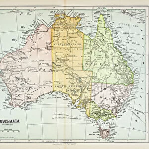
Greetings Card : Australia 1851


![]()
Cards from MapSeeker
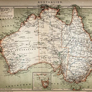
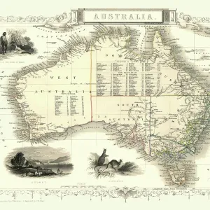
Australia 1851
A fine facimile artworked from an antique original map of the Continent of Australia, issued as part of the 1851 edition of John Tallis and Companys " The Illustrated Atlas and Modern History of the World"
Welcome to the Mapseeker Image library and enter an historic gateway to one of the largest on-line collections of Historic Maps, Nostalgic Views, Vista's and Panorama's from a World gone by.
Media ID 20347225
© Mapseeker Publishing Ltd
Continental Map John Tallis John Tallis Map Old Continental Map Tallis Map
Greetings Card (7"x5")
Introducing the Media Storehouse range of exquisite greeting cards, featuring the breathtaking artwork "Australia 1851" by John Tallis and John Rapkin from MapSeeker. This fine facsimile is derived from an original antique map of the Australian continent, published in the 1851 edition of John Tallis and Company's "The Illustrated Atlas." Each card captures the historical charm and intricate detail of this iconic map, making it a thoughtful and unique choice for any special occasion. Send a piece of history with every greeting.
Folded Greeting Cards (12.5x17.5 cm) have a laminate finish and are supplied with an envelope. The front and inside can be personalised with text in a selection of fonts, layouts and colours.
Greetings Cards suitable for Birthdays, Weddings, Anniversaries, Graduations, Thank You and much more
Estimated Product Size is 12.5cm x 17.5cm (4.9" x 6.9")
These are individually made so all sizes are approximate
Artwork printed orientated as per the preview above, with landscape (horizontal) or portrait (vertical) orientation to match the source image.
FEATURES IN THESE COLLECTIONS
> Arts
> Artists
> T
> John Tallis
> Maps and Charts
> Related Images
> Maps and Charts
> World
> MapSeeker
> Maps of Africa and Oceana
> Old Maps of Australia PORTFOLIO
EDITORS COMMENTS
This exquisite print showcases a remarkable piece of history - the Australia 1851 map, meticulously reproduced from an antique original by John Tallis and Company. Part of their renowned "The Illustrated Atlas and Modern History of the World" this edition holds immense significance for cartography enthusiasts and historians alike. Capturing the essence of a bygone era, this old map of Australia transports us back to 1851 when exploration was at its peak. The intricate details on this fine facsimile artwork provide a captivating glimpse into the continent's past. From vast uncharted territories to established settlements, every line tells a story waiting to be unraveled. John Tallis' expertise in creating visually stunning maps is evident in his collaboration with talented artist John Rapkin. Together, they have beautifully depicted not only Australia but also its surrounding regions on this continental map. This old Australian map serves as a testament to their dedication towards accuracy and artistry. As we gaze upon this mesmerizing print, our imagination takes flight, envisioning intrepid explorers venturing into unexplored lands or settlers forging new paths across rugged terrains. It reminds us of Australia's rich heritage and diverse landscapes that have shaped its identity over time. Whether you are an avid collector or simply fascinated by historical artifacts, owning this print allows you to cherish a tangible piece of history while admiring the craftsmanship behind it. Let your walls come alive with nostalgia as you proudly display this extraordinary work created by two visionary minds - John Tallis and
MADE IN AUSTRALIA
Safe Shipping with 30 Day Money Back Guarantee
FREE PERSONALISATION*
We are proud to offer a range of customisation features including Personalised Captions, Color Filters and Picture Zoom Tools
SECURE PAYMENTS
We happily accept a wide range of payment options so you can pay for the things you need in the way that is most convenient for you
* Options may vary by product and licensing agreement. Zoomed Pictures can be adjusted in the Cart.