Greetings Card > Arts > Artists > K > Johannes van Keulen
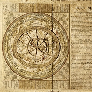
Greetings Card : Celestial map by Johannes Van Keulen (1654-1715)
")

")

![]()
Cards from Mary Evans Picture Library
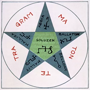
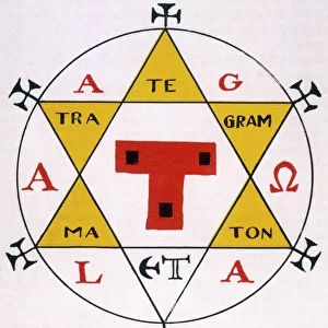
Celestial map by Johannes Van Keulen (1654-1715)
Celestial map by Johannes Van Keulen (1654-1715). SPAIN. Barcelona. Barcelona Maritime Museum
Mary Evans Picture Library makes available wonderful images created for people to enjoy over the centuries
Media ID 8260903
© Mary Evans Picture Library 2015 - https://copyrighthub.org/s0/hub1/creation/maryevans/MaryEvansPictureID/10681524
Astrological Astrology Astronomical Astronomy Atlas Barcelona Calendar Calendars Celestial Constellation Constellations Johannes Maritime Sciences Scientific Scientist Scientists Universe Keulen
Greetings Card (7"x5")
Discover the enchanting world of stars and constellations with our exquisite range of greeting cards from Media Storehouse. Featuring the mesmerizing "Celestial map by Johannes Van Keulen (1654-1715)" obtained from the esteemed Mary Evans Prints Online, these cards transport you to a universe of wonder and exploration. Each card is a work of art, showcasing intricate detail and historical significance. Perfect for astronomy enthusiasts, stargazers, or anyone seeking to add a touch of the cosmos to their correspondence, our Media Storehouse Celestial map greeting cards are a must-have. Send a message that reaches for the stars!
Folded Greeting Cards (12.5x17.5 cm) have a laminate finish and are supplied with an envelope. The front and inside can be personalised with text in a selection of fonts, layouts and colours.
Greetings Cards suitable for Birthdays, Weddings, Anniversaries, Graduations, Thank You and much more
Estimated Product Size is 12.5cm x 17.5cm (4.9" x 6.9")
These are individually made so all sizes are approximate
Artwork printed orientated as per the preview above, with landscape (horizontal) or portrait (vertical) orientation to match the source image.
FEATURES IN THESE COLLECTIONS
> Arts
> Artists
> K
> Johannes van Keulen
> Europe
> Spain
> Related Images
> Maps and Charts
> Related Images
> Maps and Charts
> Spain
> Science
> Scientists
EDITORS COMMENTS
This stunning celestial map, titled "Atlas Celestis" and created by the Dutch astronomer Johannes Van Keulen in 1676, is a testament to the scientific advancements of the late 17th century. Housed in the Barcelona Maritime Museum in Spain, this intricately detailed print showcases the known constellations of the northern and southern hemispheres, as well as the zodiac signs and various celestial bodies. Van Keulen, a renowned scientist and cartographer, meticulously depicted the stars and their constellations in vibrant colors, providing an accurate representation of the night sky at the time. The map's horizontal orientation, a departure from the traditional vertical format, allowed for a more comprehensive view of the celestial sphere. The inclusion of various calendars and astronomical information further underscores the map's scientific significance. The "Atlas Celestis" served as an essential tool for navigators, sailors, and astronomers, enabling them to navigate the seas and chart the stars. Van Keulen's celestial map is a remarkable example of the intersection of science, art, and cartography during the Age of Discovery. Its presence in the Barcelona Maritime Museum is a reminder of Spain's rich history in maritime exploration and scientific discovery. The intricate details and vibrant colors of this map continue to captivate viewers, transporting them to the wondrous depths of the universe and the vast expanse of the sea.
MADE IN AUSTRALIA
Safe Shipping with 30 Day Money Back Guarantee
FREE PERSONALISATION*
We are proud to offer a range of customisation features including Personalised Captions, Color Filters and Picture Zoom Tools
SECURE PAYMENTS
We happily accept a wide range of payment options so you can pay for the things you need in the way that is most convenient for you
* Options may vary by product and licensing agreement. Zoomed Pictures can be adjusted in the Cart.