Home > Europe > France > Canton > Nord
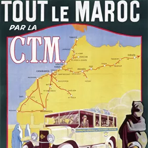
'Environs de Tanger; Afrique du nord, 1914. Creator: Unknown

![]()
Wall Art and Photo Gifts from Heritage Images
'Environs de Tanger; Afrique du nord, 1914. Creator: Unknown
'Environs de Tanger; Afrique du nord, 1914. From "Grande Geographie Bong Illustree", 1914
Heritage Images features heritage image collections
Media ID 36294605
© The Print Collector/Heritage Images
Cartography Colonies Colony Map Making Mapmaking Moroccan Morocco North Africa North African Straits Of Gibraltar Tangier Province De Tanger Morocco
FEATURES IN THESE COLLECTIONS
> Africa
> Morocco
> Related Images
> Europe
> France
> Canton
> Nord
Environs de Tanger; Afrique du Nord, 1914
EDITORS COMMENTS
is a captivating photographic print, showcasing a detailed map of the Tangier Province in Morocco, North Africa. The map, created in 1914, was originally published in the renowned German geography magazine "Grande Geographie Illustree." Despite the unknown identity of the creator, this print offers a fascinating glimpse into the colonial era of North Africa. The map meticulously illustrates the coastal regions surrounding Tangier, with the Straits of Gibraltar clearly visible in the background. The intricate cartography reveals the various provinces, towns, and settlements within Morocco, highlighting the French colonial influence with the label "Colonie Française" marking certain territories. The photograph itself is an artifact of a bygone era, showcasing the black and white engraving technique popular during the early 20th century. The contrast between the stark white borders and the intricate black lines creates an alluring visual effect, transporting viewers back in time to an era of colonial exploration and expansion. The image serves as a testament to the rich history of cartography and the role it played in shaping our understanding of the world. The mapmaking process during the colonial era was instrumental in defining and claiming territories, and this print is a tangible reminder of that period. The Tangier Province, located in modern-day Morocco, has a unique cultural heritage, blending African, European, and Middle Eastern influences. This photographic print, with its intricate map and historical significance, offers a captivating glimpse into the colonial history of North Africa and the broader context of global exploration and expansion during the 1910s.
MADE IN AUSTRALIA
Safe Shipping with 30 Day Money Back Guarantee
FREE PERSONALISATION*
We are proud to offer a range of customisation features including Personalised Captions, Color Filters and Picture Zoom Tools
SECURE PAYMENTS
We happily accept a wide range of payment options so you can pay for the things you need in the way that is most convenient for you
* Options may vary by product and licensing agreement. Zoomed Pictures can be adjusted in the Cart.