Home > Europe > France > Canton > Nord
'La Chaouia; Afrique du nord, 1914. Creator: Unknown

![]()
Wall Art and Photo Gifts from Heritage Images
'La Chaouia; Afrique du nord, 1914. Creator: Unknown
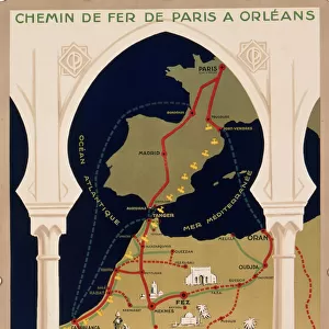
'La Chaouia; Afrique du nord, 1914. From "Grande Geographie Bong Illustree", 1914
Heritage Images features heritage image collections
Media ID 36294613
© The Print Collector/Heritage Images
Atlantic Ocean Cartography Colonies Colony Map Making Mapmaking Moroccan Morocco North Africa North African Ocean
FEATURES IN THESE COLLECTIONS
> Africa
> Morocco
> Casablanca
> Africa
> Morocco
> Related Images
> Europe
> France
> Canton
> Nord
La Chaouia; Afrique du Nord, 1914
EDITORS COMMENTS
is a captivating black and white print depicting a map of the North African coastline, specifically focusing on the region of Chaouia in Morocco. The map is an intricate engraving, showcasing the intricacies of mapmaking during the early 20th century. The print, published in "Grande Geographie Bong Illustree" in 1914, is a testament to the extensive exploration and cartographic advancements of the time. The map reveals the French colonial influence in North Africa, with French territories clearly marked in white. The map also highlights the Atlantic Ocean's role in connecting the European and African continents, with various ports and coastal towns indicated along the shoreline. The region of Chaouia, located in modern-day Morocco, is depicted with great detail, including the major cities of Casablanca, Rabat, and Safi. The map also highlights various geographical features, such as rivers, mountains, and deserts, providing a comprehensive view of the North African landscape. The print serves as a historical record of the colonial era, showcasing the European powers' expansion and influence in Africa. The intricate detail and accuracy of the map reflect the advanced cartographic techniques of the time, making it an essential addition to any collection of historical maps or African studies. Despite the print's unknown creator, it remains a valuable piece of historical documentation, providing insights into the geography and colonial history of North Africa during the early 20th century. The black and white image transports us back in time, allowing us to explore the rich history and cultural significance of this fascinating region.
MADE IN AUSTRALIA
Safe Shipping with 30 Day Money Back Guarantee
FREE PERSONALISATION*
We are proud to offer a range of customisation features including Personalised Captions, Color Filters and Picture Zoom Tools
SECURE PAYMENTS
We happily accept a wide range of payment options so you can pay for the things you need in the way that is most convenient for you
* Options may vary by product and licensing agreement. Zoomed Pictures can be adjusted in the Cart.