Home > Africa > Egypt > Maps
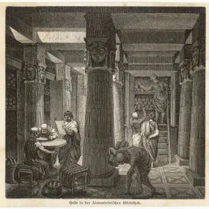
Map of Alexandria, Egypt, 17th century

![]()
Wall Art and Photo Gifts from Heritage Images
Map of Alexandria, Egypt, 17th century
Heritage Images features heritage image collections
Media ID 14873076
© Artmedia / Heritage-Images
Alexandria Cartography Map Making Mediterranean Sea Port Print Collector3
FEATURES IN THESE COLLECTIONS
> Africa
> Egypt
> Alexandria
> Africa
> Egypt
> Related Images
> Maps and Charts
> Related Images
EDITORS COMMENTS
This print showcases a beautifully detailed "Map of Alexandria, Egypt" from the 17th century. The map, created with intricate cartography techniques, offers a glimpse into the geography and layout of this historic city located on the coast of Egypt. The vibrant colors used in this art media bring life to the map, highlighting important features such as the bustling harbor and trade routes that made Alexandria a significant port during that era. Ships can be seen gracefully navigating through the Mediterranean Sea, symbolizing the importance of water transport for both commerce and exploration. As one explores this ancient city through the lens of this map, it becomes evident how its strategic location played a crucial role in shaping its history. The attention to detail is remarkable; every street and landmark is meticulously depicted, allowing viewers to immerse themselves in an authentic representation of 17th-century Alexandria. Created by AccuSoft Inc. , this print serves as a testament to their dedication towards preserving historical artifacts like maps. It captures not only an essential piece of Egyptian history but also pays homage to centuries-old traditions of map making. Whether you are an enthusiast fascinated by cartography or simply intrigued by ancient civilizations and their transportation systems, this stunning print will undoubtedly transport you back in time to explore the rich heritage embedded within Alexandria's streets and shores.
MADE IN AUSTRALIA
Safe Shipping with 30 Day Money Back Guarantee
FREE PERSONALISATION*
We are proud to offer a range of customisation features including Personalised Captions, Color Filters and Picture Zoom Tools
SECURE PAYMENTS
We happily accept a wide range of payment options so you can pay for the things you need in the way that is most convenient for you
* Options may vary by product and licensing agreement. Zoomed Pictures can be adjusted in the Cart.