Home > Animals > Reptiles > Snakes > Viper > River Jack
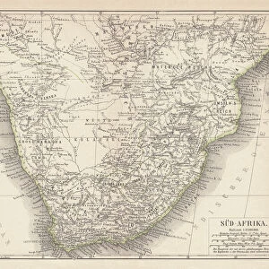
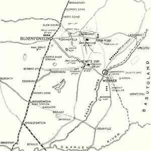
Map of the Seat of War in South Africa, 1901. Creator: John Bartholomew

![]()
Wall Art and Photo Gifts from Heritage Images
Map of the Seat of War in South Africa, 1901. Creator: John Bartholomew
Map of the Seat of War in South Africa, 1901. Map showing Bechuanaland, Transvaal Colony, Orange River Colony, Natal, Basutoland and Cape Colony, the theatre of war during the Boer Wars (1880-1902), fought between the British and the Boers. From " The Life and Deeds of Earl Roberts, Vol. IV. - To Lord Robertss Reign in Pall Mall", by J. Maclaren Cobban. [T. C. & E. C. Jack, Edinburgh, 1901]
Heritage Images features heritage image collections
Media ID 19048169
© The Print Collector/Heritage Images
1899 1902 1st Earl Roberts 2nd Boer War And E Baron Roberts Of Kandahar And Waterford Bartholomew Biography Boer Wars Cape Colony Cobban Colony Earl Roberts Field Marshal Frederick Sleigh Roberts Field Marshal Lord Roberts Frederick Roberts Frederick Sleigh Frederick Sleigh Roberts General Roberts Imperial Imperialism J Maclaren J Maclaren Cobban Jack James Maclaren James Maclaren Cobban John Bartholomew Lord Lord Frederick Sleigh Lord Frederick Sleigh Roberts Lord Roberts Lord Roberts Of Kandahar Maclaren Maclaren Cobban Natal Orange River Colony Pretoria And Waterford Roberts Second Boer War Second Transvaal War South Africa Tc And Ec Tc And Ec Jack Transvaal Basutoland Bechuanaland Lesotho
FEATURES IN THESE COLLECTIONS
> Africa
> Lesotho
> Related Images
> Africa
> Related Images
> Africa
> South Africa
> Maps
> Africa
> South Africa
> Pretoria
> Africa
> South Africa
> Related Images
> Animals
> Reptiles
> Snakes
> River Jack
> Animals
> Reptiles
> Snakes
> Viper
> River Jack
> Arts
> Artists
> F
> John Field
> Arts
> Artists
> M
> John Marshal
EDITORS COMMENTS
Map of the Seat of War in South Africa, 1901. Creator: John Bartholomew (Map of the Seat of War in South Africa, 1901. Map showing Bechuanaland, Transvaal Colony, Orange River Colony, Natal, Basutoland and Cape Colony, the theatre of war during the Boer Wars (1880-1902), fought between the British and the Boers. From ". The Life and Deeds of Earl Roberts, Vol. IV. - To Lord Robertss Reign in Pall Mall", by J. Maclaren Cobban. This print showcases a historical map that holds immense significance as it depicts the theater of war during one of South Africa's most tumultuous periods - The Boer Wars (1880-1902). Created by renowned cartographer John Bartholomew in 1901, this map provides a comprehensive view of Bechuanaland, Transvaal Colony, Orange River Colony, Natal, Basutoland and Cape Colony – all key locations embroiled in this conflict. The map serves as a visual representation that transports us back to an era marked by intense colonial struggles between Britain and the Boers. It captures both the imperialistic ambitions driving these conflicts and their impact on various regions within South Africa. Through its vibrant colors and intricate details meticulously crafted by Bartholomew himself; we gain insight into how geography played a crucial role in shaping military strategies during this time period. As we observe this historic artifact today with awe-inspiring curiosity; it reminds us to reflect upon our past while appreciating how far we have come since then. This print is not just an image but rather a gateway to understanding our shared history.
MADE IN AUSTRALIA
Safe Shipping with 30 Day Money Back Guarantee
FREE PERSONALISATION*
We are proud to offer a range of customisation features including Personalised Captions, Color Filters and Picture Zoom Tools
SECURE PAYMENTS
We happily accept a wide range of payment options so you can pay for the things you need in the way that is most convenient for you
* Options may vary by product and licensing agreement. Zoomed Pictures can be adjusted in the Cart.