Home > Arts > Artists > A > John White Alexander
Map of the Trentino Front, 1916. Creator: Unknown

![]()
Wall Art and Photo Gifts from Heritage Images
Map of the Trentino Front, 1916. Creator: Unknown
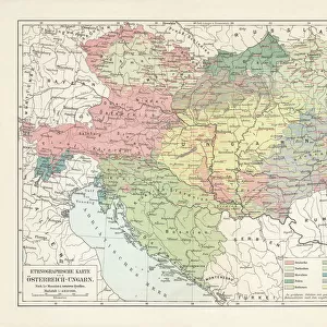
Map of the Trentino Front, 1916. On the Italian Front a series of battles at the border between Austria-Hungary and Italy were fought between 1915 and 1918. From " The War Illustrated Album De Luxe - Volume VI. The Spring and Summer Campaign of 1916", edited by J. A. Hammerton. [The Amalgamated Press, Limited, London, 1916]
Heritage Images features heritage image collections
Media ID 19661289
© The Print Collector/Heritage Images
Album Amalgamated Press Amalgamated Press Limited Amalgamated Press Ltd Front Line Frontline Hammerton Hammerton J A Hammerton Ja Hammerton Sir John Alexander Italian Front J A Hammerton Ja Hammerton John Hammerton Sir John Alexander Sir John Alexander Hammerton Sir John Hammerton Spring And Summer Campaign Of 1916 The Amalgamated Press The War Illustrated Trentino Trento Tyrol Tyrolean 1st World War Battlefield Wartime
FEATURES IN THESE COLLECTIONS
> Arts
> Artists
> A
> John White Alexander
> Arts
> Artists
> W
> John White
> Europe
> Austria
> Related Images
> Europe
> Hungary
> Related Images
EDITORS COMMENTS
This print showcases a historical artifact from the First World War - a Map of the Trentino Front, 1916. The creator remains unknown, but their work has left an indelible mark on history. This map played a crucial role in documenting the series of battles that took place between Austria-Hungary and Italy from 1915 to 1918. Taken from "The War Illustrated Album De Luxe - Volume VI" edited by J. A. Hammerton, this image transports us back to a time when Europe was engulfed in conflict. It offers a glimpse into the strategic importance of Trento, located in the Tyrol region of Italy. As we study this detailed map, we can almost envision the intense military operations that unfolded along this front line during the spring and summer campaign of 1916. The Italian forces fiercely fought against their Austrian-Hungarian counterparts for control over this critical territory. This print serves as both a historical record and a reminder of the sacrifices made during wartime. It allows us to reflect on how borders were redrawn and nations reshaped by these monumental events. Although its creator may remain anonymous, this Map of the Trentino Front stands as an enduring testament to human resilience amidst adversity. Its presence reminds us not only of our past but also encourages us to strive for peace in our present and future endeavors.
MADE IN AUSTRALIA
Safe Shipping with 30 Day Money Back Guarantee
FREE PERSONALISATION*
We are proud to offer a range of customisation features including Personalised Captions, Color Filters and Picture Zoom Tools
SECURE PAYMENTS
We happily accept a wide range of payment options so you can pay for the things you need in the way that is most convenient for you
* Options may vary by product and licensing agreement. Zoomed Pictures can be adjusted in the Cart.