Home > Arts > Artists > W > John White
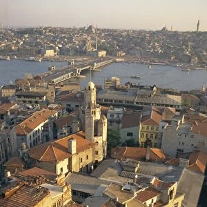
Plan of Constantinople and its Suburbs, 1856. Creator: John Dower

![]()
Wall Art and Photo Gifts from Heritage Images
Plan of Constantinople and its Suburbs, 1856. Creator: John Dower
Plan of Constantinople and its Suburbs, 1856. Map showing the city of Constantinople (modern Istanbul, Turkey), including the Golden Horn or the Port'; the Bosphorus or Channel of Constantinople, leading to the Black Sea'; the Sea of Marmora, the Armenian, Frank and Jews Quarters, pontoon bridge and the Seraglio. From "Illustrated London News", 1856
Heritage Images features heritage image collections
Media ID 36320234
© /Heritage Images
Asia Minor Bosphorus Coastline Constantinople Dower J Dower John Dower John James Golden Horn Istanbul Turkey J Dower John Dower John James Dower Sea Of Marmara Stamboul Strait Strait Of Istanbul Turkey Turkish Waterway
FEATURES IN THESE COLLECTIONS
> Animals
> Mammals
> Cricetidae
> Golden Mouse
> Architecture
> Bridges
> Bosphorus Bridge, Turkey
> Arts
> Artists
> W
> John White
> Asia
> Armenia
> Related Images
> Asia
> Turkey
> Related Images
> Europe
> Armenia
> Related Images
EDITORS COMMENTS
This black and white print, titled 'Plan of Constantinople and its Suburbs' by John Dower, was published in the Illustrated London News in 1856. The meticulously detailed map showcases the city of Constantinople, now known as Istanbul, Turkey, during the 19th century. The image highlights several notable features, including the 'Golden Horn' or the Port, the 'Bosphorus' or the Channel of Constantinople, leading to the Black Sea, and the 'Sea of Marmara'. The city's diverse quarters are also depicted, such as the Armenian, Frank, and Jewish Quarters. A pontoon bridge and the Seraglio are also visible in this intricately engraved representation. This historical map provides a fascinating glimpse into the geography and layout of Constantinople during a significant period in its rich history. John Dower's masterful illustration was originally published in the Illustrated London News, a renowned British newspaper, offering a valuable record of the city's topography and urban development during the 19th century.
MADE IN AUSTRALIA
Safe Shipping with 30 Day Money Back Guarantee
FREE PERSONALISATION*
We are proud to offer a range of customisation features including Personalised Captions, Color Filters and Picture Zoom Tools
SECURE PAYMENTS
We happily accept a wide range of payment options so you can pay for the things you need in the way that is most convenient for you
* Options may vary by product and licensing agreement. Zoomed Pictures can be adjusted in the Cart.