Home > Europe > United Kingdom > Scotland > Edinburgh > Edinburgh
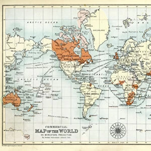
World Map showing the British Empire, 1902. Creator: Unknown

![]()
Wall Art and Photo Gifts from Heritage Images
World Map showing the British Empire, 1902. Creator: Unknown
World Map showing the British Empire, 1902. British possessions coloured red. From The Century Atlas of the World. [John Walker & Co, Ltd. London, 1902]
Heritage Images features heritage image collections
Media ID 15512790
© The Print Collector / Heritage-Images
Cartography Edinburgh Geographical Institute Imperialism Map Making World British Empire Mercator Projection
FEATURES IN THESE COLLECTIONS
> Europe
> United Kingdom
> Scotland
> Edinburgh
> Edinburgh
> Europe
> United Kingdom
> Scotland
> Lothian
> Edinburgh
> Maps and Charts
> British Empire Maps
> Maps and Charts
> Related Images
> Maps and Charts
> World
EDITORS COMMENTS
This print showcases a World Map from 1902, revealing the vast extent of the British Empire during its peak. The creator remains unknown, but their meticulous cartography skills are evident in this masterpiece. The map is adorned with vibrant red hues highlighting the extensive British possessions scattered across the globe. Taken from "The Century Atlas of the World" published by John Walker & Co. , Ltd. in London, this historical artifact provides a glimpse into an era defined by colonialism and imperialism. It serves as a testament to Britain's dominance and influence over various territories worldwide. Crafted using the Mercator projection technique, this map accurately depicts geographical locations while emphasizing British control through color symbolism. Each red-tinted region represents a piece of land under British rule, showcasing their global reach and power at that time. The Edinburgh Geographical Institute played a significant role in producing this remarkable map, contributing to its accuracy and detail. Preserved by The Print Collector for future generations to appreciate, it stands as both an educational resource and a reminder of Britain's imperial past. As we observe this historic image today, let us reflect on how maps like these shaped our understanding of the world back then. They not only served practical purposes but also perpetuated narratives of power dynamics between nations during an era marked by exploration and conquest
MADE IN AUSTRALIA
Safe Shipping with 30 Day Money Back Guarantee
FREE PERSONALISATION*
We are proud to offer a range of customisation features including Personalised Captions, Color Filters and Picture Zoom Tools
SECURE PAYMENTS
We happily accept a wide range of payment options so you can pay for the things you need in the way that is most convenient for you
* Options may vary by product and licensing agreement. Zoomed Pictures can be adjusted in the Cart.