Jigsaw Puzzle > Europe > Spain > Maps
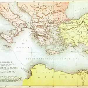
Jigsaw Puzzle : 19Th Century Map Showing Provinces And Cities Of Roman Spain


![]()
Jigsaw Puzzles from Design Pics
19Th Century Map Showing Provinces And Cities Of Roman Spain
Design Pics offers Distinctively Different Imagery representing over 1,500 contributors
Media ID 18188512
© Ken Welsh / Design Pics
Cartography Cities Drawings Engravings Illustrations Prints Provinces Roman Spain Spanish Nineteenth
Jigsaw Puzzle (500 Pieces)
Discover the rich history of ancient Rome with our captivating jigsaw puzzle from Media Storehouse. This intricately detailed puzzle, featuring a 19th century map of the provinces and cities of Roman Spain by Ken Welsh from Design Pics, is the perfect project for history enthusiasts and puzzle lovers alike. Immerse yourself in the intricacies of this historical map, as you piece together the provinces and cities that once formed part of the vast Roman Empire. Each puzzle piece fits seamlessly into place, bringing the map to life and transporting you back in time. A challenging yet rewarding experience, our Roman Spain jigsaw puzzle is sure to provide hours of enjoyment and serve as a beautiful conversation starter in your home or office.
500 piece puzzles are custom made in Australia and hand-finished on 100% recycled 1.6mm thick laminated puzzle boards. There is a level of repetition in jigsaw shapes with each matching piece away from its pair. The completed puzzle measures 40x51cm and is delivered packaged in an attractive presentation box specially designed to fit most mail slots with a unique magnetic lid
Jigsaw Puzzles are an ideal gift for any occasion
Estimated Product Size is 50.7cm x 40.3cm (20" x 15.9")
These are individually made so all sizes are approximate
Artwork printed orientated as per the preview above, with landscape (horizontal) or portrait (vertical) orientation to match the source image.
FEATURES IN THESE COLLECTIONS
> Maps and Charts
> Related Images
> Maps and Charts
> Spain
EDITORS COMMENTS
This 19th-century map, skillfully crafted by Ken Welsh, takes us on a journey back in time to the Roman era in Spain. A true masterpiece of cartography, this print showcases the provinces and cities that once thrived under Roman rule. With its horizontal layout, it effortlessly captures the vastness of this ancient empire's influence. As we delve into every intricate detail of this illustration, we are transported to a world where names like Hispania Tarraconensis and Baetica hold great significance. The carefully etched lines depict borders that defined these regions centuries ago, while delicate engravings highlight major cities such as Corduba (modern-day Córdoba) and Emerita Augusta (now Mérida). The artistic finesse with which Ken Welsh has brought this historical map to life is truly commendable. Each stroke tells a story of conquests and cultural exchange that shaped the landscape we know today as Spain. This print serves not only as an educational tool but also as a window into the past for those who appreciate history's rich tapestry. Whether displayed in a classroom or adorning the walls of an avid historian's study, this 19th-century map offers endless possibilities for exploration and discovery. It invites us to marvel at the grandeur of Roman Spain while reminding us how far our world has come since then.
MADE IN AUSTRALIA
Safe Shipping with 30 Day Money Back Guarantee
FREE PERSONALISATION*
We are proud to offer a range of customisation features including Personalised Captions, Color Filters and Picture Zoom Tools
SECURE PAYMENTS
We happily accept a wide range of payment options so you can pay for the things you need in the way that is most convenient for you
* Options may vary by product and licensing agreement. Zoomed Pictures can be adjusted in the Cart.