Jigsaw Puzzle > Fine Art Finder > Artists > G > Giovanni Xenodocus da Corfu Giovanni
Jigsaw Puzzle : The Central Mediterranean, from a nautical atlas, 1520 (ink on vellum) (see also
 (see also")
 (see also")


Please select a smaller print size for this image
![]()
Jigsaw Puzzles from Fine Art Finder
The Central Mediterranean, from a nautical atlas, 1520 (ink on vellum) (see also
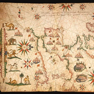
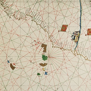
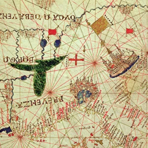
XOT330915 The Central Mediterranean, from a nautical atlas, 1520 (ink on vellum) (see also ) by Giovanni Xenodocus da Corfu (fl. 16th Century); 32x22.3 cm; Museo Correr, Venice, Italy; Greek, out of copyright
Media ID 12852589
© www.bridgemanimages.com
Adriatic Sea Chart Corsica Croatia Ionian Sea Mapping Portolan Sardinia Sicily
Jigsaw Puzzle (500 Pieces)
Discover the rich history of cartography with our exquisite Media Storehouse Jigsaw Puzzle featuring 'The Central Mediterranean' from a 1520 nautical atlas. This intricately detailed puzzle, inspired by a rare ink on vellum artwork by Giovanni Xenodocus da Corfu, invites you on a captivating journey through the Mediterranean Sea as it appeared over 500 years ago. Immerse yourself in the intricacies of the Old World's maritime exploration and connect with the past piece by piece. Perfect for history enthusiasts, puzzle collectors, or anyone seeking a challenging and rewarding pastime.
500 piece puzzles are custom made in Australia and hand-finished on 100% recycled 1.6mm thick laminated puzzle boards. There is a level of repetition in jigsaw shapes with each matching piece away from its pair. The completed puzzle measures 40x51cm and is delivered packaged in an attractive presentation box specially designed to fit most mail slots with a unique magnetic lid
Jigsaw Puzzles are an ideal gift for any occasion
Estimated Product Size is 50.7cm x 40.3cm (20" x 15.9")
These are individually made so all sizes are approximate
Artwork printed orientated as per the preview above, with landscape (horizontal) or portrait (vertical) orientation to match the source image.
FEATURES IN THESE COLLECTIONS
> Fine Art Finder
> Artists
> G
> Giovanni Xenodocus da Corfu Giovanni
> Fine Art Finder
> Artists
> Giovanni Xenodocus da Corfu
EDITORS COMMENTS
This print takes us back in time to the year 1520, when Giovanni Xenodocus da Corfu created an exquisite nautical atlas. The image showcases the Central Mediterranean region, beautifully rendered with ink on vellum. Measuring 32x22.3 cm, this historical masterpiece is now housed in the Museo Correr in Venice, Italy. As we gaze upon this ancient map, our eyes are drawn to the intricate details that bring life to its surface. From Italy's boot-shaped peninsula and the enchanting islands of Corsica, Sardinia, and Sicily to North Africa's coastline and Croatia's Adriatic Sea shores - every contour has been meticulously depicted by da Corfu. The artistry of cartography shines through as we marvel at how effortlessly da Corfu captured the essence of these lands and seas. This portolan chart not only serves as a navigational tool but also stands as a testament to human curiosity and exploration during that era. Transported by this visual journey through time, one can almost imagine sailors relying on similar maps for their daring voyages across treacherous waters. It reminds us of how far we have come in terms of mapping technology while appreciating the ingenuity required by those who came before us. Thanks to Fine Art Finder and www. bridgemanimages. com for preserving this remarkable piece of history for all generations to admire and learn from. Let it serve as a reminder that even centuries-old works continue to inspire awe and fascination
MADE IN AUSTRALIA
Safe Shipping with 30 Day Money Back Guarantee
FREE PERSONALISATION*
We are proud to offer a range of customisation features including Personalised Captions, Color Filters and Picture Zoom Tools
SECURE PAYMENTS
We happily accept a wide range of payment options so you can pay for the things you need in the way that is most convenient for you
* Options may vary by product and licensing agreement. Zoomed Pictures can be adjusted in the Cart.