Home > Europe > Italy > Sicily > Messina
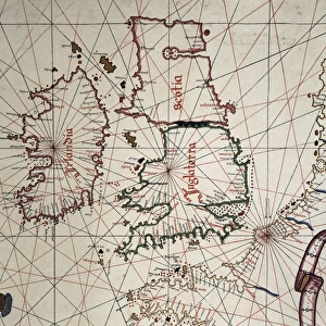
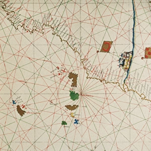
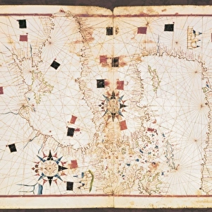
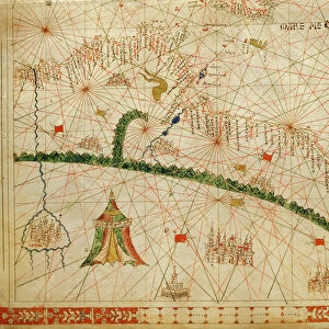
Portolan chart, 1587. Map of England, Scotland

![]()
Wall Art and Photo Gifts from Mary Evans Picture Library
Portolan chart, 1587. Map of England, Scotland
Portolan chart, 1587. Map of England, Scotland and Ireland with the north France coast. Realized in Messina. Facsimile. Renaissance art. Miniature Painting
Mary Evans Picture Library makes available wonderful images created for people to enjoy over the centuries
Media ID 8284275
© Mary Evans Picture Library 2015 - https://copyrighthub.org/s0/hub1/creation/maryevans/MaryEvansPictureID/10681998
Banner Banners Chart Facsimile Geographic Geographical Geography Illuminated Manuscript Manuscripts Messina Miniatures Portolan Renaissance Scot Land
FEATURES IN THESE COLLECTIONS
> Arts
> Art Movements
> Renaissance Art
> Europe
> Italy
> Sicily
> Messina
> Europe
> Republic of Ireland
> Maps
> Europe
> Republic of Ireland
> Paintings
> Europe
> United Kingdom
> England
> Maps
> Europe
> United Kingdom
> England
> Paintings
> Europe
> United Kingdom
> Scotland
> Maps
> Europe
> United Kingdom
> Scotland
> Paintings
EDITORS COMMENTS
1. Title: A Glimpse into the Past: The Portolan Chart of 1587 - A Vibrant Testament to Renaissance Cartography This image showcases a Portolan chart, a rare and exquisite example of Renaissance cartography from 1587. This intricately detailed map, realized in Messina, Italy, offers a fascinating glimpse into the geographical knowledge of the time. The chart focuses on the regions of England, Scotland, and Ireland, as well as the north French coast. The map is adorned with richly illuminated elements, including banners and flags, adding a vibrant and decorative touch to the geographical information presented. The intricate miniature painting style, characteristic of the Renaissance period, is evident in the meticulously rendered coastlines, islands, and place names. The Portolan chart is an essential piece of cartographic history, representing a significant advancement in the understanding and representation of geography during the late 16th century. The chart's intricate details, such as the winding coastlines and the precise placement of islands, demonstrate the advanced cartographic techniques of the time. The map's depiction of the British Isles and the north French coast is particularly noteworthy, as it reflects the expanding knowledge of European explorers and traders during the Renaissance. The inclusion of place names, many of which are still in use today, further underscores the map's historical significance. This facsimile of the Portolan chart is a testament to the rich artistic and cartographic traditions of the Renaissance period. It invites us to explore the world as it was known during this time, and to marvel at the ingenuity and creativity of the cartographers and artists who brought it to life.
MADE IN AUSTRALIA
Safe Shipping with 30 Day Money Back Guarantee
FREE PERSONALISATION*
We are proud to offer a range of customisation features including Personalised Captions, Color Filters and Picture Zoom Tools
SECURE PAYMENTS
We happily accept a wide range of payment options so you can pay for the things you need in the way that is most convenient for you
* Options may vary by product and licensing agreement. Zoomed Pictures can be adjusted in the Cart.