Jigsaw Puzzle > Fine Art Finder > Maps (celestial & Terrestrial)
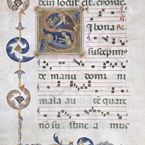
Jigsaw Puzzle : Map of the Atlantic Ocean, c. 1550 (vellum)
")
")


![]()
Jigsaw Puzzles from Fine Art Finder
Map of the Atlantic Ocean, c. 1550 (vellum)
XIR182124 Map of the Atlantic Ocean, c.1550 (vellum) by Portuguese School, (16th century); Bibliotheque Nationale, Paris, France; Portuguese, out of copyright
Media ID 12702473
© www.bridgemanimages.com
Capricorn Equator National Tropic Of Cancer
Jigsaw Puzzle (500 Pieces)
Discover the mysteries of the past with our exquisite Jigsaw Puzzle from Media Storehouse, featuring the enchanting "Map of the Atlantic Ocean, c.1550 (vellum)" by the Portuguese School. This intricate puzzle, inspired by an original map housed in the Bibliotheque Nationale in Paris, France, invites you on a captivating journey through time. Immerse yourself in the history of exploration as you piece together this stunning representation of a 16th-century map, now out of copyright. Each puzzle piece, carefully crafted to resemble the aged vellum texture of the original, adds to the authenticity of your historical adventure. Experience the thrill of discovery as you unveil the intricate details of this fine art masterpiece, one piece at a time.
500 piece puzzles are custom made in Australia and hand-finished on 100% recycled 1.6mm thick laminated puzzle boards. There is a level of repetition in jigsaw shapes with each matching piece away from its pair. The completed puzzle measures 40x51cm and is delivered packaged in an attractive presentation box specially designed to fit most mail slots with a unique magnetic lid
Jigsaw Puzzles are an ideal gift for any occasion
Estimated Product Size is 50.7cm x 40.3cm (20" x 15.9")
These are individually made so all sizes are approximate
Artwork printed orientated as per the preview above, with landscape (horizontal) or portrait (vertical) orientation to match the source image.
FEATURES IN THESE COLLECTIONS
> Fine Art Finder
> Maps (celestial & Terrestrial)
> Fine Art Finder
> Schools
> Portuguese School
EDITORS COMMENTS
This print showcases a remarkable piece of history - the Map of the Atlantic Ocean, created around 1550 by the Portuguese School. Crafted on vellum and now housed in the prestigious Bibliotheque Nationale in Paris, France, this map offers a glimpse into the intricate cartographic knowledge of its time. The map encompasses vast stretches of ocean, depicting key geographical features such as the Tropic of Cancer, Capricorn, and Equator. With meticulous detail, it highlights various continents including Great Britain, Africa, and South America. Each landmass is adorned with national flags and coats of arms that add an element of cultural significance to this historical artifact. As we delve into this mesmerizing artwork captured by www. bridgemanimages. com's lens, we are transported back to an era when exploration was at its peak. The delicate craftsmanship exhibited on vellum reflects not only technical expertise but also serves as a testament to mankind's insatiable curiosity about our world. Beyond being a mere visual representation of geographic boundaries, this image invites us to reflect upon our collective human journey through time. It reminds us how far we have come in terms of understanding our planet while igniting a sense of wonder for what lies beyond those distant horizons. In preserving and sharing images like these from Fine Art Finder's collection without commercial intent or mention thereof; we honor both artistry and history alike - ensuring that future generations can continue to appreciate their beauty and significance.
MADE IN AUSTRALIA
Safe Shipping with 30 Day Money Back Guarantee
FREE PERSONALISATION*
We are proud to offer a range of customisation features including Personalised Captions, Color Filters and Picture Zoom Tools
SECURE PAYMENTS
We happily accept a wide range of payment options so you can pay for the things you need in the way that is most convenient for you
* Options may vary by product and licensing agreement. Zoomed Pictures can be adjusted in the Cart.