Jigsaw Puzzle > Fine Art Storehouse > Map
Jigsaw Puzzle : Map of Kentucky and Tennessee


![]()
Jigsaw Puzzles from Fine Art Storehouse
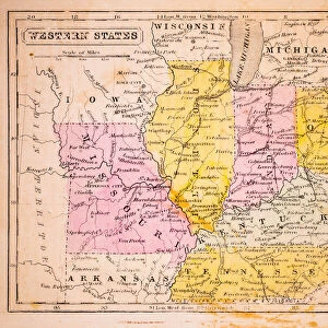
Map of Kentucky and Tennessee
Map of Kentucky and Tennessee - 1886 scanned engraving
Unleash your creativity and transform your space into a visual masterpiece!
benoitb
Media ID 13667275
© This content is subject to copyright
American Civil War Canada Kentucky Mississippi River Sketch State Tennessee Classical Style Nashville Tennessee River Victorian Style
Jigsaw Puzzle (1000 Pieces)
Discover the rich history and geography of the American South with our stunning 'Map of Kentucky and Tennessee' jigsaw puzzle from the Media Storehouse collection. This intricately detailed puzzle features a beautiful 1886 scanned engraving by benoitb from the Fine Art Storehouse. Piece together the borders, rivers, and cities of these two iconic states, and immerse yourself in the history and culture that made them unique. A perfect activity for puzzle enthusiasts, history buffs, or anyone looking for a challenging and rewarding experience. Bring the beauty of the past into your home with this captivating jigsaw puzzle.
1000 piece puzzles are custom made in Australia and hand-finished on 100% recycled 1.6mm thick laminated puzzle boards. There is a level of repetition in jigsaw shapes with each matching piece away from its pair. The completed puzzle measures 76x50cm and is delivered packaged in an attractive presentation box specially designed to fit most mail slots with a unique magnetic lid
Jigsaw Puzzles are an ideal gift for any occasion
Estimated Product Size is 76cm x 50.2cm (29.9" x 19.8")
These are individually made so all sizes are approximate
Artwork printed orientated as per the preview above, with landscape (horizontal) or portrait (vertical) orientation to match the source image.
FEATURES IN THESE COLLECTIONS
> Fine Art Storehouse
> History
> Battles & Wars
> American Civil War (1860-1865)
> Fine Art Storehouse
> Map
> Historical Maps
> Fine Art Storehouse
> Map
> USA Maps
EDITORS COMMENTS
This print takes us back in time to the year 1886, where we find ourselves immersed in a detailed map of Kentucky and Tennessee. The scanned engraving showcases the intricate craftsmanship of this historical piece, capturing the essence of an era long gone. The map itself is a testament to the significance of these two states during the American Civil War. It highlights key landmarks such as the Mississippi River, Nashville, and the Tennessee River, reminding us of their strategic importance during that tumultuous period in history. Rendered in a Victorian style with classical influences, this engraved image transports us to a bygone era when maps were meticulously hand-drawn works of art. Its antique charm evokes nostalgia for simpler times and invites us to explore every intricate detail etched onto its surface. As we gaze upon this remarkable print against its pristine white background, we are reminded not only of our rich past but also how far we have come since then. This 19th-century masterpiece serves as a visual reminder of our shared history and offers an opportunity for reflection on how it has shaped our present-day world. Benoitb's skillful preservation and presentation allow us to appreciate this historical gem anew while honoring its timeless beauty.
MADE IN AUSTRALIA
Safe Shipping with 30 Day Money Back Guarantee
FREE PERSONALISATION*
We are proud to offer a range of customisation features including Personalised Captions, Color Filters and Picture Zoom Tools
SECURE PAYMENTS
We happily accept a wide range of payment options so you can pay for the things you need in the way that is most convenient for you
* Options may vary by product and licensing agreement. Zoomed Pictures can be adjusted in the Cart.