Metal Print > Fine Art Storehouse > Map
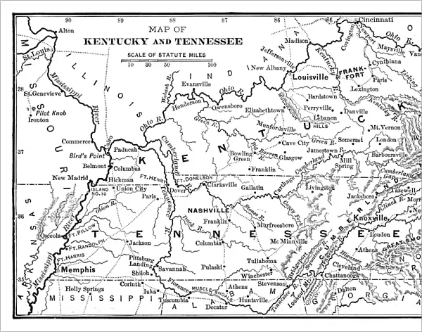
Metal Print : Map of Kentucky and Tennessee


![]()
Metal Prints from Fine Art Storehouse
Map of Kentucky and Tennessee
Map of Kentucky and Tennessee - 1886 scanned engraving
Unleash your creativity and transform your space into a visual masterpiece!
benoitb
Media ID 13667275
© This content is subject to copyright
American Civil War Canada Kentucky Mississippi River Sketch State Tennessee Classical Style Nashville Tennessee River Victorian Style
14"x11" (28x35cm) Metal Print
Bring history to life with our stunning Metal Print of a vintage map of Kentucky and Tennessee, taken from an 1886 engraving by benoitb from Fine Art Storehouse. This beautiful piece showcases intricate details of the topography, rivers, and borders of the two states in an elegant, timeless design. The high-quality metal print process ensures vibrant colors and a durable, waterproof finish. Perfect for adding a unique touch to any room or office space, this map print makes a great conversation starter and a cherished addition to your home decor.
Our Metal Prints feature rounded corners and rear fixings for easy wall mounting. Images are directly printed onto a lightweight, high quality 5mm thick, durable metallic surface for a vivid and vibrant finish. Available in 2 sizes, 28x35cm (14x11) and 50x40cm (20x16). The unique material is fade, moisture, chemical and scratch resistant to help ensure this art lasts a lifetime.
Made with durable metal and luxurious printing techniques, metal prints bring images to life and add a modern touch to any space
Estimated Product Size is 35.5cm x 27.9cm (14" x 11")
These are individually made so all sizes are approximate
Artwork printed orientated as per the preview above, with landscape (horizontal) or portrait (vertical) orientation to match the source image.
FEATURES IN THESE COLLECTIONS
> Fine Art Storehouse
> History
> Battles & Wars
> American Civil War (1860-1865)
> Fine Art Storehouse
> Map
> Historical Maps
> Fine Art Storehouse
> Map
> USA Maps
EDITORS COMMENTS
This print takes us back in time to the year 1886, where we find ourselves immersed in a detailed map of Kentucky and Tennessee. The scanned engraving showcases the intricate craftsmanship of this historical piece, capturing the essence of an era long gone. The map itself is a testament to the significance of these two states during the American Civil War. It highlights key landmarks such as the Mississippi River, Nashville, and the Tennessee River, reminding us of their strategic importance during that tumultuous period in history. Rendered in a Victorian style with classical influences, this engraved image transports us to a bygone era when maps were meticulously hand-drawn works of art. Its antique charm evokes nostalgia for simpler times and invites us to explore every intricate detail etched onto its surface. As we gaze upon this remarkable print against its pristine white background, we are reminded not only of our rich past but also how far we have come since then. This 19th-century masterpiece serves as a visual reminder of our shared history and offers an opportunity for reflection on how it has shaped our present-day world. Benoitb's skillful preservation and presentation allow us to appreciate this historical gem anew while honoring its timeless beauty.
MADE IN AUSTRALIA
Safe Shipping with 30 Day Money Back Guarantee
FREE PERSONALISATION*
We are proud to offer a range of customisation features including Personalised Captions, Color Filters and Picture Zoom Tools
SECURE PAYMENTS
We happily accept a wide range of payment options so you can pay for the things you need in the way that is most convenient for you
* Options may vary by product and licensing agreement. Zoomed Pictures can be adjusted in the Cart.