Jigsaw Puzzle > Fine Art Storehouse > Map
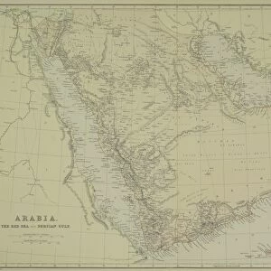
Jigsaw Puzzle : Antique map of Arabia with Egypt, Nubia, and Abyssinia


![]()
Jigsaw Puzzles from Fine Art Storehouse
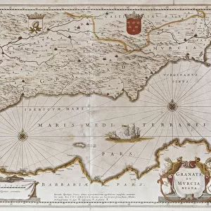
Antique map of Arabia with Egypt, Nubia, and Abyssinia
Unleash your creativity and transform your space into a visual masterpiece!
Hemera Technologies
Media ID 13609459
© Getty Images
Abyssinia Arabian Peninsula Border Direction Document Egypt Ethiopia Geography Horn Of Africa Indian Ocean Iran Latitude Legend Location Longitude Middle East Nubia Persia Persian Gulf Place Positioning Red Sea Saudi Arabia Scale
Jigsaw Puzzle (500 Pieces)
Discover the rich history of ancient Arabia with our exquisite jigsaw puzzle from the Media Storehouse collection. This intricately detailed puzzle features an antique map of Arabia, Egypt, Nubia, and Abyssinia, brought to you by Fine Art Storehouse and Hemera Technologies. Transport yourself back in time as you piece together this beautiful representation of historical geography, perfect for puzzle enthusiasts and history buffs alike. Engage your mind and immerse yourself in the intricacies of this captivating puzzle, making it a wonderful addition to any home or office.
500 piece puzzles are custom made in Australia and hand-finished on 100% recycled 1.6mm thick laminated puzzle boards. There is a level of repetition in jigsaw shapes with each matching piece away from its pair. The completed puzzle measures 40x51cm and is delivered packaged in an attractive presentation box specially designed to fit most mail slots with a unique magnetic lid
Jigsaw Puzzles are an ideal gift for any occasion
Estimated Product Size is 50.7cm x 40.3cm (20" x 15.9")
These are individually made so all sizes are approximate
Artwork printed orientated as per the preview above, with landscape (horizontal) or portrait (vertical) orientation to match the source image.
FEATURES IN THESE COLLECTIONS
> Fine Art Storehouse
> Map
> Historical Maps
EDITORS COMMENTS
This antique map of Arabia with Egypt, Nubia, and Abyssinia takes us on a journey through time. Crafted by Hemera Technologies, this archival print showcases the intricate details of cartography from a bygone era. The rich history and cultural significance of the Arabian Peninsula are beautifully depicted in this vintage piece. The map highlights key locations such as Saudi Arabia, Iran, Ethiopia, and the Horn of Africa. It provides an invaluable glimpse into the physical geography of the region, showcasing borders, latitude lines, longitude markers, and even a scale for measurement. The Red Sea and Persian Gulf stand out prominently as important waterways that have shaped trade routes throughout history. Engraved with precision and attention to detail, this historic document offers more than just geographical information; it tells stories of ancient civilizations that once thrived in these lands. As we gaze upon this color image without any people present in it, we can't help but imagine the bustling markets along the coastlines or camel caravans traversing vast deserts. Whether you're a lover of history or simply appreciate fine art photography like this one from Fine Art Storehouse's collection - "Antique map of Arabia with Egypt" is sure to captivate your imagination and transport you back in time to an era where exploration was at its peak.
MADE IN AUSTRALIA
Safe Shipping with 30 Day Money Back Guarantee
FREE PERSONALISATION*
We are proud to offer a range of customisation features including Personalised Captions, Color Filters and Picture Zoom Tools
SECURE PAYMENTS
We happily accept a wide range of payment options so you can pay for the things you need in the way that is most convenient for you
* Options may vary by product and licensing agreement. Zoomed Pictures can be adjusted in the Cart.