Jigsaw Puzzle > Arts > Landscape paintings > Landscape art > Landscape paintings
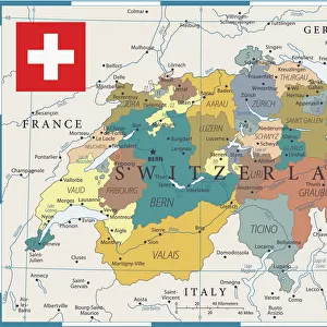
Jigsaw Puzzle : Geological map of southern Germany, Bohemia, Switzerland and Austria, published 1897


![]()
Jigsaw Puzzles from Fine Art Storehouse
Geological map of southern Germany, Bohemia, Switzerland and Austria, published 1897
Geological map of southern and central Germany, Bohemia, Switzerland and Austria. Lithograph, published in 1897
Unleash your creativity and transform your space into a visual masterpiece!
Media ID 14756156
© This content is subject to copyright
Austria Bohemia Devon European Alps Geology Igneous Igneous Rock Slate Soil Switzerland Volcanic Carbon Geological Map Jura Minerals Multi Colored Quaternary Silurian Tertiary
Jigsaw Puzzle (500 Pieces)
Discover the wonders of geology with our exquisite Jigsaw Puzzle from Media Storehouse, featuring a captivating lithograph of a Geological Map of Southern Germany, Bohemia, Switzerland, and Austria, published in 1897 from our Fine Art Storehouse collection. Delve into the intricacies of the Earth's history as you piece together this intricately detailed puzzle, transporting you back in time to the late 19th century. Ideal for geology enthusiasts, history buffs, or anyone seeking a challenging and educational puzzle experience. Immerse yourself in the beauty of this historical map and uncover the stories hidden within its lines and colors.
500 piece puzzles are custom made in Australia and hand-finished on 100% recycled 1.6mm thick laminated puzzle boards. There is a level of repetition in jigsaw shapes with each matching piece away from its pair. The completed puzzle measures 40x51cm and is delivered packaged in an attractive presentation box specially designed to fit most mail slots with a unique magnetic lid
Jigsaw Puzzles are an ideal gift for any occasion
Estimated Product Size is 50.7cm x 40.3cm (20" x 15.9")
These are individually made so all sizes are approximate
Artwork printed orientated as per the preview above, with landscape (horizontal) or portrait (vertical) orientation to match the source image.
FEATURES IN THESE COLLECTIONS
> Fine Art Storehouse
> Map
> Historical Maps
> Arts
> Landscape paintings
> Landscape art
> Landscape paintings
> Europe
> Austria
> Related Images
> Europe
> Germany
> Related Images
> Europe
> Related Images
> Europe
> Switzerland
> Maps
> Europe
> Switzerland
> Posters
EDITORS COMMENTS
This lithograph, published in 1897, showcases a detailed geological map of southern Germany, Bohemia, Switzerland, and Austria. A true testament to the scientific advancements of its time, this print provides a glimpse into the rich history and diverse landscapes of these European regions. The intricate details on this map highlight various geological features that shaped the land over millions of years. From the towering peaks of the European Alps to the sprawling plains dotted with minerals and precious resources, every inch tells a story of Earth's evolution. Layers upon layers are unveiled as we explore this artwork - from quaternary deposits to ancient carbon formations; from Devonian rock formations to igneous outcrops; from slate quarries to Silurian sediments. The map also reveals significant periods such as Jura, Tertiary, Trias - each contributing unique characteristics to these lands. Vibrant colors bring life to this lithograph while providing visual cues about soil composition and volcanic activity across the region. Its horizontal layout allows for easy navigation through an array of information meticulously engraved onto its surface. As we gaze at this remarkable piece, it serves not only as a historical record but also as a reminder that beneath our feet lies an awe-inspiring tapestry woven by nature itself. Whether you're fascinated by geology or simply appreciate fine artistry capturing our planet's wonders – let this exquisite print transport you back in time and ignite your curiosity about Earth's magnificent past.
MADE IN AUSTRALIA
Safe Shipping with 30 Day Money Back Guarantee
FREE PERSONALISATION*
We are proud to offer a range of customisation features including Personalised Captions, Color Filters and Picture Zoom Tools
SECURE PAYMENTS
We happily accept a wide range of payment options so you can pay for the things you need in the way that is most convenient for you
* Options may vary by product and licensing agreement. Zoomed Pictures can be adjusted in the Cart.