Jigsaw Puzzle > Maps and Charts > Turkey
Jigsaw Puzzle : Map of european Turkey 1900


![]()
Jigsaw Puzzles from Fine Art Storehouse
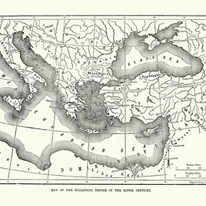
Map of european Turkey 1900
Meyers hand-Atlas Leipzig und Wien Verlag des Bibliographischen Instituts 1900
Unleash your creativity and transform your space into a visual masterpiece!
THEPALMER
Media ID 18106905
© 2014 Roberto Adrian Photography
Jigsaw Puzzle (500 Pieces)
Discover the rich history of Europe with our intricately detailed Jigsaw Puzzle from Media Storehouse, featuring the "Map of European Turkey 1900" by THEPALMER from Fine Art Storehouse. This captivating puzzle, derived from the pages of the esteemed Meyers Hand-Atlas published by the Bibliographisches Institut in Leipzig and Wien in 1900, invites you on an educational and engaging journey through time. With meticulously cut pieces and a high-quality finish, this puzzle promises hours of fun and satisfaction as you piece together the historical map of Europe, including the region of Turkish territories at the turn of the 20th century. Perfect for history enthusiasts, puzzle lovers, or anyone seeking a challenging and rewarding pastime.
500 piece puzzles are custom made in Australia and hand-finished on 100% recycled 1.6mm thick laminated puzzle boards. There is a level of repetition in jigsaw shapes with each matching piece away from its pair. The completed puzzle measures 40x51cm and is delivered packaged in an attractive presentation box specially designed to fit most mail slots with a unique magnetic lid
Jigsaw Puzzles are an ideal gift for any occasion
Estimated Product Size is 50.7cm x 40.3cm (20" x 15.9")
These are individually made so all sizes are approximate
Artwork printed orientated as per the preview above, with landscape (horizontal) or portrait (vertical) orientation to match the source image.
FEATURES IN THESE COLLECTIONS
> Fine Art Storehouse
> Map
> Historical Maps
> Asia
> Turkey
> Related Images
> Europe
> Related Images
EDITORS COMMENTS
This print showcases a historical gem, the "Map of European Turkey 1900" sourced from the renowned Meyers Hand-Atlas Leipzig und Wien Verlag des Bibliographischen Instituts in 1900. With its intricate details and exquisite craftsmanship, this piece takes us on a journey back in time to explore the geopolitical landscape of Europe during that era. The map itself is a testament to the artistry and precision involved in cartography. Every contour, border, and label has been meticulously etched onto paper with utmost care. It offers an intriguing glimpse into how boundaries were defined and territories were divided at the turn of the century. As we examine this vintage masterpiece, we are transported to an era when empires rose and fell, shaping history as we know it today. The delicate colors used to differentiate countries evoke a sense of nostalgia for bygone times. Each region tells its own story - from bustling cities to remote villages nestled amidst breathtaking landscapes. "The Map of European Turkey 1900" invites us to reflect upon our shared heritage while marveling at how much our world has evolved over time. It serves as a reminder that history is not merely confined within textbooks; it lives on through artifacts like this remarkable map print. Whether you're an avid historian or simply appreciate fine art, this print will undoubtedly captivate your imagination and spark conversations about Europe's rich past. Let it adorn your walls as both a stunning decorative piece and a window into another era – one that continues to shape our
MADE IN AUSTRALIA
Safe Shipping with 30 Day Money Back Guarantee
FREE PERSONALISATION*
We are proud to offer a range of customisation features including Personalised Captions, Color Filters and Picture Zoom Tools
SECURE PAYMENTS
We happily accept a wide range of payment options so you can pay for the things you need in the way that is most convenient for you
* Options may vary by product and licensing agreement. Zoomed Pictures can be adjusted in the Cart.