Jigsaw Puzzle > Europe > France > Canton > Landes
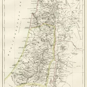
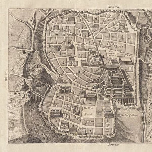
Jigsaw Puzzle : Map showing the mountain ranges of Palestine


![]()
Jigsaw Puzzles from Fine Art Storehouse
Map showing the mountain ranges of Palestine
Vintage engraving of Map showing the mountain ranges of Palestine, 19th Century
Unleash your creativity and transform your space into a visual masterpiece!
duncan1890
Media ID 14719385
© This content is subject to copyright
Asia Minor Asia Pac Equipment Ground Historical Geopolitical Location Historical Palestine Israel Judea Land Land Feature Middle East Natural Phenomenon Navigational Equipment Palestine Retro Styles Supplies
Jigsaw Puzzle (500 Pieces)
Discover the rich history and geography of Palestine with our stunning Jigsaw Puzzle from Media Storehouse. Featuring a vintage engraving by duncan1890 from Fine Art Storehouse, this 19th-century map showcases the magnificent mountain ranges that have shaped the landscape of this historic region. Engage in a captivating puzzle experience as you piece together this intricate and detailed representation of Palestine's breathtaking topography. Perfect for history enthusiasts, geography buffs, and puzzle lovers alike, this Jigsaw Puzzle is a beautiful addition to any home or office.
500 piece puzzles are custom made in Australia and hand-finished on 100% recycled 1.6mm thick laminated puzzle boards. There is a level of repetition in jigsaw shapes with each matching piece away from its pair. The completed puzzle measures 40x51cm and is delivered packaged in an attractive presentation box specially designed to fit most mail slots with a unique magnetic lid
Jigsaw Puzzles are an ideal gift for any occasion
Estimated Product Size is 40.3cm x 50.7cm (15.9" x 20")
These are individually made so all sizes are approximate
Artwork printed orientated as per the preview above, with landscape (horizontal) or portrait (vertical) orientation to match the source image.
FEATURES IN THESE COLLECTIONS
> Fine Art Storehouse
> Map
> Historical Maps
> Asia
> Israel
> Related Images
> Asia
> Palestine
> Related Images
> Asia
> Related Images
> Europe
> France
> Canton
> Landes
> Maps and Charts
> Early Maps
> Maps and Charts
> Related Images
EDITORS COMMENTS
This vintage engraving takes us back to the 19th century, offering a glimpse into the historical geopolitical location of Palestine. The print showcases a meticulously detailed map that highlights the magnificent mountain ranges of this ancient land. With its old-fashioned charm and woodcut style, it exudes an air of nostalgia and authenticity. The illustration transports us to a time when cartography was both an art form and a scientific endeavor. It is evident that great care was taken in depicting every land feature, as well as providing accurate navigational equipment for explorers of that era. As we study this piece, we are reminded of the rich history associated with Palestine – from biblical stories set in Judea to its significance within Asia Minor. The mountain ranges depicted on this map stand tall as natural phenomena, shaping the landscape and influencing life in these regions throughout centuries. Duncan1890's print captures not only the beauty but also the essence of historical Palestine. Its antique allure invites us to appreciate how far our understanding has come since those early days of exploration and mapping techniques. This artwork serves as a reminder that even though time may have passed, there is always value in revisiting the past through artistic interpretations like this one.
MADE IN AUSTRALIA
Safe Shipping with 30 Day Money Back Guarantee
FREE PERSONALISATION*
We are proud to offer a range of customisation features including Personalised Captions, Color Filters and Picture Zoom Tools
SECURE PAYMENTS
We happily accept a wide range of payment options so you can pay for the things you need in the way that is most convenient for you
* Options may vary by product and licensing agreement. Zoomed Pictures can be adjusted in the Cart.