Jigsaw Puzzle > Maps and Charts > Americas
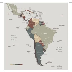
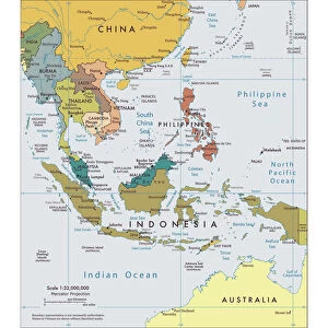
Jigsaw Puzzle : Physical map of South America


![]()
Jigsaw Puzzles from Fine Art Storehouse
Physical map of South America
Vector illustration of the physical map of South America
Reference map was created by the US Central Intelligence Agency and is available as a public domain map at the University of Texas Libraries website
Unleash your creativity and transform your space into a visual masterpiece!
Media ID 15192870
Jigsaw Puzzle (500 Pieces)
Discover the wonders of South America with our captivating jigsaw puzzles from Media Storehouse. Featuring intricate detail and vibrant colors, this puzzle showcases a physical map of South America, expertly crafted from a fine art vector illustration. Originally created by the US Central Intelligence Agency and now available as a public domain map at the University of Texas Libraries, this puzzle is not only a fun and engaging activity, but also an educational experience. Immerse yourself in the rich cultural heritage and diverse landscapes of South America as you piece together the intricate puzzle. Perfect for puzzle enthusiasts, geography buffs, or anyone looking for a challenging and rewarding activity. Add this beautiful and educational puzzle to your collection today!
500 piece puzzles are custom made in Australia and hand-finished on 100% recycled 1.6mm thick laminated puzzle boards. There is a level of repetition in jigsaw shapes with each matching piece away from its pair. The completed puzzle measures 40x51cm and is delivered packaged in an attractive presentation box specially designed to fit most mail slots with a unique magnetic lid
Jigsaw Puzzles are an ideal gift for any occasion
Estimated Product Size is 40.3cm x 50.7cm (15.9" x 20")
These are individually made so all sizes are approximate
Artwork printed orientated as per the preview above, with landscape (horizontal) or portrait (vertical) orientation to match the source image.
FEATURES IN THESE COLLECTIONS
> Fine Art Storehouse
> Map
> Reference Maps
> Maps and Charts
> Related Images
> South America
> Related Images
EDITORS COMMENTS
Discover the breathtaking beauty of South America through this stunning physical map print. With intricate details and vibrant colors, this vector illustration captures the diverse landscapes that make up this continent. From the majestic peaks of the Andes Mountains to the lush Amazon rainforest, every geographical feature is meticulously depicted. This reference map, created by the US Central Intelligence Agency and made available as a public domain map at the University of Texas Libraries website, offers an authentic representation of South America's topography. Whether you are an avid traveler or simply fascinated by geography, this artwork serves as both an educational tool and a visual delight. Immerse yourself in its rich tapestry as you trace your fingers along winding rivers like the mighty Amazon or explore coastal plains stretching for miles on end. Marvel at Patagonia's icy glaciers contrasting with Argentina's fertile pampas. Feel a sense of wonderment as you navigate through dense jungles teeming with exotic wildlife. Perfect for home decor or office spaces, this fine art print adds sophistication and intrigue to any setting. Let it transport you to far-off lands and ignite your wanderlust for adventure in one of Earth's most enchanting regions – South America.
MADE IN AUSTRALIA
Safe Shipping with 30 Day Money Back Guarantee
FREE PERSONALISATION*
We are proud to offer a range of customisation features including Personalised Captions, Color Filters and Picture Zoom Tools
SECURE PAYMENTS
We happily accept a wide range of payment options so you can pay for the things you need in the way that is most convenient for you
* Options may vary by product and licensing agreement. Zoomed Pictures can be adjusted in the Cart.