Jigsaw Puzzle > Fine Art Storehouse > Map
Jigsaw Puzzle : Central states eastern division map 1889


![]()
Jigsaw Puzzles from Fine Art Storehouse
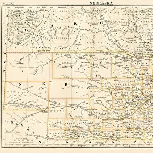
Central states eastern division map 1889
Indiana Educational Series The Complete Geography - Indianapolis 1889
Unleash your creativity and transform your space into a visual masterpiece!
THEPALMER
Media ID 14756350
© This content is subject to copyright
Illinois Indiana Kentucky Michigan North America Ohio United States Virginia West Virginia Wisconsin
Jigsaw Puzzle (500 Pieces)
Discover the history of the Central States with our intricately designed jigsaw puzzle from the Media Storehouse and Fine Art Storehouse collection. This captivating puzzle features the Central States Eastern Division Map of 1889 by THEPALMER from the Indianapolis 1889 Indiana Education Series. Immerse yourself in the detailed depiction of the geography of the Central States during this time period. A perfect addition to any home or classroom, this jigsaw puzzle is not only a fun and engaging activity but also an educational tool that will transport you back in time. Piece together history and create a beautiful display that will spark curiosity and conversation.
500 piece puzzles are custom made in Australia and hand-finished on 100% recycled 1.6mm thick laminated puzzle boards. There is a level of repetition in jigsaw shapes with each matching piece away from its pair. The completed puzzle measures 40x51cm and is delivered packaged in an attractive presentation box specially designed to fit most mail slots with a unique magnetic lid
Jigsaw Puzzles are an ideal gift for any occasion
Estimated Product Size is 40.3cm x 50.7cm (15.9" x 20")
These are individually made so all sizes are approximate
Artwork printed orientated as per the preview above, with landscape (horizontal) or portrait (vertical) orientation to match the source image.
FEATURES IN THESE COLLECTIONS
> Fine Art Storehouse
> Map
> Historical Maps
> Fine Art Storehouse
> Map
> USA Maps
EDITORS COMMENTS
This print takes us back in time to the year 1889, where we find ourselves exploring the intricacies of the Central States Eastern Division. Titled "Central States Eastern Division Map 1889" this piece is part of the Indiana Educational Series called "The Complete Geography - Indianapolis 1889". The artist behind this remarkable work is known as THEPALMER. As our eyes delve into this vintage map, we are transported to a bygone era when cartography was meticulously hand-drawn and filled with rich details. This particular map showcases several states within its borders, including Illinois, Indiana, Kentucky, Michigan, Ohio, Virginia, West Virginia, and Wisconsin. It offers a comprehensive view of these regions' geographical features and highlights their importance within North America. The fine craftsmanship evident in every stroke captivates viewers and invites them to embark on an imaginary journey through time. Each state's boundaries are carefully outlined while rivers gracefully meander across the landscape. Mountains rise majestically from the paper's surface as if inviting exploration. "The Central States Eastern Division Map 1889" serves not only as a historical artifact but also as a testament to human curiosity and exploration. Its presence adds depth and character to any space it graces—a perfect addition for history enthusiasts or those seeking a touch of nostalgia. With THEPALMER's artistic prowess combined with Fine Art Storehouse's commitment to preserving such treasures for future generations—this print ensures that history remains alive through artistry.
MADE IN AUSTRALIA
Safe Shipping with 30 Day Money Back Guarantee
FREE PERSONALISATION*
We are proud to offer a range of customisation features including Personalised Captions, Color Filters and Picture Zoom Tools
SECURE PAYMENTS
We happily accept a wide range of payment options so you can pay for the things you need in the way that is most convenient for you
* Options may vary by product and licensing agreement. Zoomed Pictures can be adjusted in the Cart.