Metal Print > Fine Art Storehouse > Map
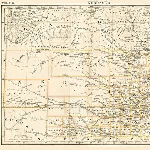
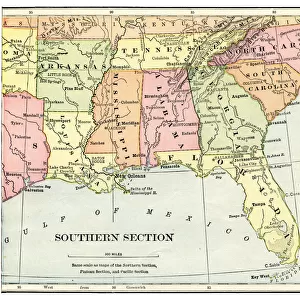
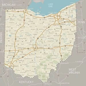
Metal Print : Central states eastern division map 1889


![]()
Metal Prints from Fine Art Storehouse
Central states eastern division map 1889
Indiana Educational Series The Complete Geography - Indianapolis 1889
Unleash your creativity and transform your space into a visual masterpiece!
THEPALMER
Media ID 14756350
© This content is subject to copyright
Illinois Indiana Kentucky Michigan North America Ohio United States Virginia West Virginia Wisconsin
10"x8" (25x20cm) Table Top Metal Print
Discover history through the captivating art of our Metal Prints. This piece features a vintage Central States Eastern Division Map from 1889, originally published in the Indiana Educational Series The Complete Geography by THEPALMER. Each Metal Print is meticulously crafted with high-quality materials, resulting in a stunning, vibrant image that adds depth and texture to any space. The map's intricate details and rich history are brought to life in a contemporary way, making it a unique and thought-provoking addition to your home or office decor. Experience the past in a new light with our Metal Prints.
Table Top Metal Prints feature rounded corners and an easel back for easy display. Available in two sizes, 18x13cm (7x5) or 25x20cm (10x8). Lightweight and vibrant, they are perfect for displaying artwork and are guaranteed to add style to any desk or table top. The unique material is fade, moisture, chemical and scratch resistant to help ensure this art lasts a lifetime.
Made with durable metal and luxurious printing techniques, metal prints bring images to life and add a modern touch to any space
Estimated Product Size is 20.3cm x 25.4cm (8" x 10")
These are individually made so all sizes are approximate
Artwork printed orientated as per the preview above, with landscape (horizontal) or portrait (vertical) orientation to match the source image.
FEATURES IN THESE COLLECTIONS
> Fine Art Storehouse
> Map
> Historical Maps
> Fine Art Storehouse
> Map
> USA Maps
EDITORS COMMENTS
This print takes us back in time to the year 1889, where we find ourselves exploring the intricacies of the Central States Eastern Division. Titled "Central States Eastern Division Map 1889" this piece is part of the Indiana Educational Series called "The Complete Geography - Indianapolis 1889". The artist behind this remarkable work is known as THEPALMER. As our eyes delve into this vintage map, we are transported to a bygone era when cartography was meticulously hand-drawn and filled with rich details. This particular map showcases several states within its borders, including Illinois, Indiana, Kentucky, Michigan, Ohio, Virginia, West Virginia, and Wisconsin. It offers a comprehensive view of these regions' geographical features and highlights their importance within North America. The fine craftsmanship evident in every stroke captivates viewers and invites them to embark on an imaginary journey through time. Each state's boundaries are carefully outlined while rivers gracefully meander across the landscape. Mountains rise majestically from the paper's surface as if inviting exploration. "The Central States Eastern Division Map 1889" serves not only as a historical artifact but also as a testament to human curiosity and exploration. Its presence adds depth and character to any space it graces—a perfect addition for history enthusiasts or those seeking a touch of nostalgia. With THEPALMER's artistic prowess combined with Fine Art Storehouse's commitment to preserving such treasures for future generations—this print ensures that history remains alive through artistry.
MADE IN AUSTRALIA
Safe Shipping with 30 Day Money Back Guarantee
FREE PERSONALISATION*
We are proud to offer a range of customisation features including Personalised Captions, Color Filters and Picture Zoom Tools
SECURE PAYMENTS
We happily accept a wide range of payment options so you can pay for the things you need in the way that is most convenient for you
* Options may vary by product and licensing agreement. Zoomed Pictures can be adjusted in the Cart.