Jigsaw Puzzle > Europe > France > Maps
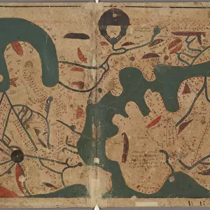
Jigsaw Puzzle : Carte du Tendre: imaginary map by a character in the novel Cl├®lie


![]()
Jigsaw Puzzles from Fine Art Storehouse
Carte du Tendre: imaginary map by a character in the novel Cl├®lie
Madeleine de Scudery, often known simply as Mademoiselle de Scudery, was a French writer. Illustration of a Carte du Tendre: imaginary map by a character in the novel Cl├®lie by Mademoiselle de Scudery, 1654. In Cl├®lie, Scud├®ry invented the famous Carte de Tendre, a map of an Arcadia where the geography is all based around the theme of love
Unleash your creativity and transform your space into a visual masterpiece!
Nastasic
Media ID 18298721
Jigsaw Puzzle (1000 Pieces)
Discover the captivating world of Mademoiselle de Scudery's "Carte du Tendre" with our exquisite jigsaw puzzles from Media Storehouse's Fine Art Collection. This enchanting illustration, inspired by the novel "Clélie" by Nastasic, invites you on a journey through the lands of romantic love. Each intricately designed piece brings the vibrant colors and whimsical details of this imaginary map to life. Unleash your creativity and immerse yourself in the rich history and artistry of this fascinating work. Solve the puzzle, piece by piece, and cherish the beauty of this timeless masterpiece in your home.
1000 piece puzzles are custom made in Australia and hand-finished on 100% recycled 1.6mm thick laminated puzzle boards. There is a level of repetition in jigsaw shapes with each matching piece away from its pair. The completed puzzle measures 76x50cm and is delivered packaged in an attractive presentation box specially designed to fit most mail slots with a unique magnetic lid
Jigsaw Puzzles are an ideal gift for any occasion
Estimated Product Size is 76cm x 50.2cm (29.9" x 19.8")
These are individually made so all sizes are approximate
Artwork printed orientated as per the preview above, with landscape (horizontal) or portrait (vertical) orientation to match the source image.
FEATURES IN THESE COLLECTIONS
> Fine Art Storehouse
> Map
> Historical Maps
> Fine Art Storehouse
> Top Sellers - Art Prints
> Maps and Charts
> Related Images
EDITORS COMMENTS
This print showcases the intricate beauty of the "Carte du Tendre" an imaginary map created by a character in Mademoiselle de Scudery's novel, Clélie. Crafted in 1654, this illustration transports us to a world where love reigns supreme and geography is intertwined with matters of the heart. In Clélie, Scudéry masterfully weaves together a tale set in Arcadia, an idyllic paradise depicted on this very map. As we gaze upon its delicate details, we are transported into a realm where rivers flow with affection and mountains rise as symbols of devotion. Each landmark represents various stages and aspects of love: from the treacherous paths of Doubt to the enchanting gardens of Blissful Union. The Carte du Tendre serves not only as a visual representation but also as a metaphorical guide for navigating the complexities of human emotions. It invites us to explore our own emotional landscapes and discover hidden territories within ourselves. Nastasic's skillful capture allows us to appreciate every stroke and contour that brings this imaginary world to life. The soft hues evoke feelings of nostalgia while reminding us that love has been both cherished and pondered throughout history. As we admire this remarkable piece, let it serve as a reminder that even within fiction lies profound wisdom about human connections. Let it inspire us to embark on our own journey through the landscape of love, guided by imagination and fueled by passion.
MADE IN AUSTRALIA
Safe Shipping with 30 Day Money Back Guarantee
FREE PERSONALISATION*
We are proud to offer a range of customisation features including Personalised Captions, Color Filters and Picture Zoom Tools
SECURE PAYMENTS
We happily accept a wide range of payment options so you can pay for the things you need in the way that is most convenient for you
* Options may vary by product and licensing agreement. Zoomed Pictures can be adjusted in the Cart.