Jigsaw Puzzle > Granger Art on Demand > Maps
Jigsaw Puzzle : MAP: NORTH PACIFIC. Nouvelle Carte des ecouvertes faites par des Vaisseaux Russiens


![]()
Jigsaw Puzzles from Granger
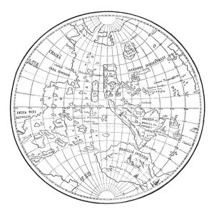
MAP: NORTH PACIFIC. Nouvelle Carte des ecouvertes faites par des Vaisseaux Russiens
MAP: NORTH PACIFIC.
Nouvelle Carte des ecouvertes faites par des Vaisseaux Russiens, showing the voyage of the Great Northern Expedition led by Vitus Bering, 1733-1743. Map by the St. Petersburg Academy, 1758
Granger holds millions of images spanning more than 25,000 years of world history, from before the Stone Age to the dawn of the Space Age
Media ID 12321297
1733 1743 1758 Asia Coast Danish Expedition Exploration Great North America Northern Ocean Pacific Ocean Peninsula Russian Siberia Siberian Vitus Voyage Bering Bering Strait Kamchatka
Jigsaw Puzzle (500 Pieces)
Discover the rich history of exploration with our captivating jigsaw puzzle from Media Storehouse. Featuring the intricately detailed map, "MAP: NORTH PACIFIC. Nouvelle Carte des ecouvertes faites par des Vaisseaux Russiens," this puzzle brings to life the epic journey of the Great Northern Expedition led by Vitus Bering from 1733 to 1743. This beautiful and historically significant map, sourced from The Granger Collection at Granger Art on Demand, will transport you back in time as you piece together the intricate details of this important cartographic work. Immerse yourself in the adventure and history with this challenging and rewarding puzzle.
500 piece puzzles are custom made in Australia and hand-finished on 100% recycled 1.6mm thick laminated puzzle boards. There is a level of repetition in jigsaw shapes with each matching piece away from its pair. The completed puzzle measures 40x51cm and is delivered packaged in an attractive presentation box specially designed to fit most mail slots with a unique magnetic lid
Jigsaw Puzzles are an ideal gift for any occasion
Estimated Product Size is 50.7cm x 40.3cm (20" x 15.9")
These are individually made so all sizes are approximate
Artwork printed orientated as per the preview above, with landscape (horizontal) or portrait (vertical) orientation to match the source image.
EDITORS COMMENTS
This print showcases a historical map titled "MAP: NORTH PACIFIC. Nouvelle Carte des ecouvertes faites par des Vaisseaux Russiens" which translates to "New Map of Discoveries Made by Russian Ships". Created by the St. Petersburg Academy in 1758, this map documents the remarkable voyage of the Great Northern Expedition led by Vitus Bering from 1733 to 1743. The map provides a visual narrative of Bering's expedition, highlighting his exploration and discoveries across the North Pacific region. From the Bering Strait to the coasts of Asia and North America, every detail is meticulously depicted, including rivers, peninsulas, and oceanic boundaries. As we delve into this piece of cartographic history, we are transported back in time to an era when Danish and French explorers joined forces with their Russian counterparts on a quest for knowledge and discovery. The vastness of Siberia unfolds before our eyes as we trace their footsteps through Kamchatka Peninsula and beyond. This print not only serves as a beautiful decorative piece but also offers us a glimpse into an important chapter in human exploration. It reminds us of our innate curiosity about uncharted territories and our relentless pursuit of understanding the world around us. With its rich historical significance and intricate details, this map print from The Granger Collection is sure to captivate both history enthusiasts and art lovers alike.
MADE IN AUSTRALIA
Safe Shipping with 30 Day Money Back Guarantee
FREE PERSONALISATION*
We are proud to offer a range of customisation features including Personalised Captions, Color Filters and Picture Zoom Tools
SECURE PAYMENTS
We happily accept a wide range of payment options so you can pay for the things you need in the way that is most convenient for you
* Options may vary by product and licensing agreement. Zoomed Pictures can be adjusted in the Cart.