Jigsaw Puzzle > North America > United States of America > Louisiana > New Orleans
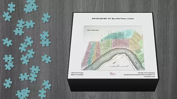
Jigsaw Puzzle : NEW ORLEANS MAP, 1837. Map of New Orleans, Louisiana


![]()
Jigsaw Puzzles from Granger
NEW ORLEANS MAP, 1837. Map of New Orleans, Louisiana
Granger holds millions of images spanning more than 25,000 years of world history, from before the Stone Age to the dawn of the Space Age
Media ID 6620115
1837 Antebellum New Orleans South East
Jigsaw Puzzle (500 Pieces)
Discover the rich history of New Orleans with our captivating jigsaw puzzle from Media Storehouse. Featuring a vintage map of the city from 1837, this puzzle brings the past to life. Meticulously reproduced from The Granger Collection, this intriguing puzzle showcases the layout of New Orleans in its early days, complete with the Mississippi River, Bayou St. John, and the historic French Quarter. Ideal for puzzle enthusiasts, history buffs, or anyone looking for a challenging and rewarding pastime, this beautiful puzzle is sure to provide hours of enjoyment and a sense of accomplishment upon completion.
500 piece puzzles are custom made in Australia and hand-finished on 100% recycled 1.6mm thick laminated puzzle boards. There is a level of repetition in jigsaw shapes with each matching piece away from its pair. The completed puzzle measures 40x51cm and is delivered packaged in an attractive presentation box specially designed to fit most mail slots with a unique magnetic lid
Jigsaw Puzzles are an ideal gift for any occasion
Estimated Product Size is 50.7cm x 40.3cm (20" x 15.9")
These are individually made so all sizes are approximate
Artwork printed orientated as per the preview above, with landscape (horizontal) or portrait (vertical) orientation to match the source image.
FEATURES IN THESE COLLECTIONS
> Granger Art on Demand
> Maps
> Arts
> Landscape paintings
> Waterfall and river artworks
> River artworks
> Maps and Charts
> Early Maps
> Maps and Charts
> Related Images
> North America
> United States of America
> Louisiana
> New Orleans
> South America
> Related Images
NEW ORLEANS MAP, 1837 - A Glimpse into the Vibrant Tapestry of Antebellum New Orleans
EDITORS COMMENTS
. Step back in time with this print of a meticulously detailed map showcasing the enchanting cityscape of New Orleans in 1837. Transport yourself to an era when horse-drawn carriages traversed cobblestone streets and grand plantation houses lined the Mississippi River. This exquisite piece from The Granger Collection offers a fascinating glimpse into the early days of one of America's most iconic cities. Every street, alleyway, and waterway is intricately depicted, allowing you to trace the footsteps of those who once called this bustling metropolis home. As you explore this historic map, your eyes will be drawn to key landmarks that have shaped New Orleans' identity over centuries. From Jackson Square with its elegant St. Louis Cathedral to the meandering curves of the mighty Mississippi River, each element tells a story about the rich cultural heritage that defines this unique southern gem. Whether you are an avid history enthusiast or simply captivated by beautiful cartography, this print is sure to ignite your imagination and transport you back in time. Hang it proudly on your wall as a testament to both American ingenuity and our enduring fascination with preserving our past. Discover anew the allure and charm that made New Orleans such a captivating destination then - just as it continues to be today.
MADE IN AUSTRALIA
Safe Shipping with 30 Day Money Back Guarantee
FREE PERSONALISATION*
We are proud to offer a range of customisation features including Personalised Captions, Color Filters and Picture Zoom Tools
SECURE PAYMENTS
We happily accept a wide range of payment options so you can pay for the things you need in the way that is most convenient for you
* Options may vary by product and licensing agreement. Zoomed Pictures can be adjusted in the Cart.