Jigsaw Puzzle > Europe > Ukraine > Maps
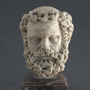
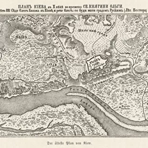
Jigsaw Puzzle : Map of Poltava in the early 18th-century. Artist: Anonymous


![]()
Jigsaw Puzzles from Heritage Images
Map of Poltava in the early 18th-century. Artist: Anonymous
Map of Poltava in the early 18th-century. Found in the collection of the State Open-air Museum Battle of Poltava, Poltava
Heritage Images features heritage image collections
Media ID 15013382
© Fine Art Images
Action Battle Of Poltava Cartography Cavalry Charles Xii Charles Xii Of Sweden Fight Great Northern War Infantry Peter Alexeyevich Peter I Peter I Alexeyevich Poltava Russian Army Russian Swedish War Russian Troops Russian Victory Schwedish Army Tsar Peter I Ukraine Copper Engraving
Jigsaw Puzzle (500 Pieces)
Discover history with our captivating jigsaw puzzle from Media Storehouse. This intricately detailed puzzle features a map of Poltava from the early 18th-century, showcasing the strategic battlefield that was the site of one of the most significant military engagements in history. Originally found in the State Open-air Museum Battle of Poltava in Poltava, Ukraine, this anonymous artwork brings the past to life. Piece together this intriguing puzzle and transport yourself back in time, as you immerse yourself in the rich tapestry of history.
500 piece puzzles are custom made in Australia and hand-finished on 100% recycled 1.6mm thick laminated puzzle boards. There is a level of repetition in jigsaw shapes with each matching piece away from its pair. The completed puzzle measures 40x51cm and is delivered packaged in an attractive presentation box specially designed to fit most mail slots with a unique magnetic lid
Jigsaw Puzzles are an ideal gift for any occasion
Estimated Product Size is 50.7cm x 40.3cm (20" x 15.9")
These are individually made so all sizes are approximate
Artwork printed orientated as per the preview above, with landscape (horizontal) or portrait (vertical) orientation to match the source image.
FEATURES IN THESE COLLECTIONS
> Europe
> Russia
> Related Images
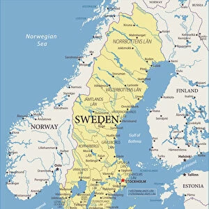
> Europe
> Sweden
> Related Images
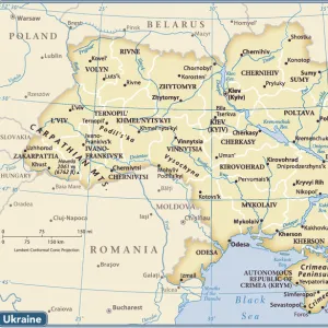
> Europe
> Ukraine
> Related Images
> Historic
> Battles
> Related Images
EDITORS COMMENTS
This print showcases a remarkable piece of history - the "Map of Poltava in the early 18th-century". Created by an anonymous artist, this map provides a fascinating glimpse into the past. Found in the collection of the State Open-air Museum Battle of Poltava in Poltava, Ukraine, it is a testament to the enduring significance of this region. The map depicts a pivotal moment during the Great Northern War between Russia and Sweden. It vividly captures the action and intensity of battle with its intricate details. From cavalry charges to infantry formations, every aspect has been meticulously illustrated through copper engraving. At its center lies Poltava, where one can almost feel the tension that once permeated these lands. This was where Tsar Peter I led his Russian troops against Charles XII and his Swedish army. The outcome would shape European history forever. It is impossible not to be drawn into this historical narrative as we contemplate how such events unfolded on these very grounds centuries ago. As we examine this fine art image, we are reminded of both triumph and tragedy - for it was here that Russia achieved a decisive victory over Sweden. This print serves as a powerful reminder that maps are not merely geographical tools but also windows into our collective past. They allow us to explore significant moments in time and appreciate their impact on our present-day world.
MADE IN AUSTRALIA
Safe Shipping with 30 Day Money Back Guarantee
FREE PERSONALISATION*
We are proud to offer a range of customisation features including Personalised Captions, Color Filters and Picture Zoom Tools
SECURE PAYMENTS
We happily accept a wide range of payment options so you can pay for the things you need in the way that is most convenient for you
* Options may vary by product and licensing agreement. Zoomed Pictures can be adjusted in the Cart.