Jigsaw Puzzle > Europe > Russia > Maps
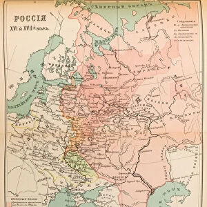
Jigsaw Puzzle : Map of the volosts and principalities in the 12th and 13th century, 1914


![]()
Jigsaw Puzzles from Heritage Images
Map of the volosts and principalities in the 12th and 13th century, 1914
Map of the volosts and principalities in the 12th and 13th century, 1914. Private Collection
Heritage Images features heritage image collections
Media ID 15047413
© / Heritage-Images
Anonymous Master Cartography Early Rus Grand Duchy Of Moscow History Of Russia Moscow Principality Muscovy Russian History Colour Lithograph
Jigsaw Puzzle (500 Pieces)
Discover history with our captivating Media Storehouse Jigsaw Puzzle featuring a map of the volosts and principalities in the 12th and 13th century. This intricately detailed puzzle, based on a rare and authentic 1914 map from Heritage Images, invites you on a journey back in time. With rich historical context, this puzzle is not just a fun activity but also an educational experience. Immerse yourself in the intricacies of medieval Europe as you piece together this captivating puzzle. Perfect for history enthusiasts, puzzle lovers, or anyone seeking a challenging and rewarding pastime.
500 piece puzzles are custom made in Australia and hand-finished on 100% recycled 1.6mm thick laminated puzzle boards. There is a level of repetition in jigsaw shapes with each matching piece away from its pair. The completed puzzle measures 40x51cm and is delivered packaged in an attractive presentation box specially designed to fit most mail slots with a unique magnetic lid
Jigsaw Puzzles are an ideal gift for any occasion
Estimated Product Size is 40.3cm x 50.7cm (15.9" x 20")
These are individually made so all sizes are approximate
Artwork printed orientated as per the preview above, with landscape (horizontal) or portrait (vertical) orientation to match the source image.
FEATURES IN THESE COLLECTIONS
> Europe
> Russia
> Related Images
> Maps and Charts
> Early Maps
> Maps and Charts
> Related Images
EDITORS COMMENTS
This print showcases a remarkable piece of history - a Map of the volosts and principalities in the 12th and 13th century. Created by an anonymous master in 1914, this colour lithograph provides a glimpse into the intricate cartography of early Rus. The map takes us back to a time when Russia was divided into various volosts and principalities, each with its own unique identity and significance. It offers valuable insights into the political landscape of that era, shedding light on the Grand Duchy of Moscow, Moscow Principality, and Muscovy. With fine artistry evident in every detail, this graphic arts masterpiece captures not only geographical boundaries but also historical narratives. It serves as an invaluable resource for those interested in delving deep into Russian history. Housed within a private collection, this portrait-like map invites viewers to embark on a journey through time. Its presence evokes curiosity about how these regions evolved over centuries and their impact on shaping modern-day Russia. While we admire this exquisite work from afar, it is important to note that commercial use is prohibited for this particular image. Nonetheless, its value lies in preserving our cultural heritage and providing us with glimpses into our rich past.
MADE IN AUSTRALIA
Safe Shipping with 30 Day Money Back Guarantee
FREE PERSONALISATION*
We are proud to offer a range of customisation features including Personalised Captions, Color Filters and Picture Zoom Tools
SECURE PAYMENTS
We happily accept a wide range of payment options so you can pay for the things you need in the way that is most convenient for you
* Options may vary by product and licensing agreement. Zoomed Pictures can be adjusted in the Cart.