Jigsaw Puzzle > Arts > Artists > T > John Tallis
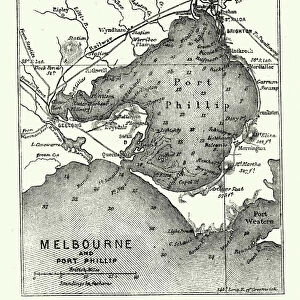
Jigsaw Puzzle : Victoria, or Port Phillip 1851


![]()
Jigsaw Puzzles from MapSeeker
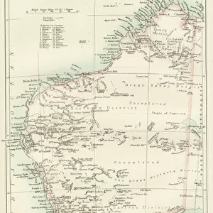
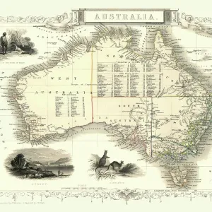
Victoria, or Port Phillip 1851
A fine facimile artworked from an antique original map of Victoria, or Port Phillip, Australia, issued as part of the 1851 edition of John Tallis and Companys " The Illustrated Atlas and Modern History of the World"
Welcome to the Mapseeker Image library and enter an historic gateway to one of the largest on-line collections of Historic Maps, Nostalgic Views, Vista's and Panorama's from a World gone by.
Media ID 20347408
© Mapseeker Publishing Ltd
John Tallis John Tallis Map Tallis Map Port Phillip
Jigsaw Puzzle (1000 Pieces)
Discover the rich history of Victoria, Australia with our exquisite jigsaw puzzles from Media Storehouse. Featuring the detailed and captivating artwork "Victoria, or Port Phillip 1851" by John Tallis and John Rapkin from MapSeeker. This fine facsimile is brought to life in puzzle form, allowing you to immerse yourself in the intricacies of this antique map of Victoria. Recreate the beauty and history of this important piece of cartography, perfect for puzzle enthusiasts and history buffs alike. Engage your mind and transport yourself back in time with this engaging and educational puzzle experience.
1000 piece puzzles are custom made in Australia and hand-finished on 100% recycled 1.6mm thick laminated puzzle boards. There is a level of repetition in jigsaw shapes with each matching piece away from its pair. The completed puzzle measures 76x50cm and is delivered packaged in an attractive presentation box specially designed to fit most mail slots with a unique magnetic lid
Jigsaw Puzzles are an ideal gift for any occasion
Estimated Product Size is 76cm x 50.2cm (29.9" x 19.8")
These are individually made so all sizes are approximate
Artwork printed orientated as per the preview above, with landscape (horizontal) or portrait (vertical) orientation to match the source image.
FEATURES IN THESE COLLECTIONS
> Arts
> Artists
> P
> John Phillip
> Arts
> Artists
> T
> John Tallis
> Maps and Charts
> Related Images
> Maps and Charts
> World
> MapSeeker
> Maps of Africa and Oceana
> Old Maps of Australia PORTFOLIO
EDITORS COMMENTS
This print showcases a remarkable piece of history - a fine facsimile artworked from an antique original map of Victoria, or Port Phillip, Australia. This extraordinary map was originally issued as part of the 1851 edition of John Tallis and Company's "The Illustrated Atlas and Modern History of the World". Transporting us back to the mid-19th century, this old map offers a glimpse into Australia's past with intricate details that highlight its rich heritage. The carefully crafted lines and delicate shading bring to life the vast expanse of Victoria, revealing its diverse landscapes and geographical features. John Tallis, renowned for his cartographic expertise, collaborated with talented artist John Rapkin to create this masterpiece. Their combined efforts resulted in a visually stunning representation that captures the essence of Victoria during this significant era. As we explore this vintage treasure, it becomes evident why maps hold such fascination for historians and enthusiasts alike. They serve as windows into bygone times, allowing us to trace the footsteps of those who came before us. Whether you are an avid collector or simply appreciate historical artifacts, this print is sure to captivate your imagination. Display it proudly on your wall as a testament to both Victorian history and the artistry involved in creating such magnificent cartographic works.
MADE IN AUSTRALIA
Safe Shipping with 30 Day Money Back Guarantee
FREE PERSONALISATION*
We are proud to offer a range of customisation features including Personalised Captions, Color Filters and Picture Zoom Tools
SECURE PAYMENTS
We happily accept a wide range of payment options so you can pay for the things you need in the way that is most convenient for you
* Options may vary by product and licensing agreement. Zoomed Pictures can be adjusted in the Cart.