Jigsaw Puzzle > Arts > Artists > T > John Tallis
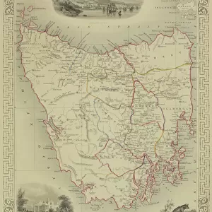
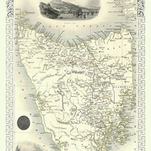
Jigsaw Puzzle : Van Diemens Island, or Tasmania 1851


![]()
Jigsaw Puzzles from MapSeeker
Van Diemens Island, or Tasmania 1851
A fine facimile artworked from an antique original map of Van Diemens Land or Tasmania, issued as part of the 1851 edition of John Tallis and Companys " The Illustrated Atlas and Modern History of the World"
Welcome to the Mapseeker Image library and enter an historic gateway to one of the largest on-line collections of Historic Maps, Nostalgic Views, Vista's and Panorama's from a World gone by.
Media ID 20347356
© Mapseeker Publishing Ltd
John Tallis John Tallis Map Tallis Map Tasmania
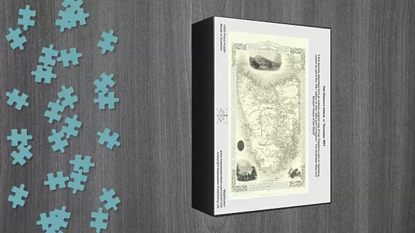
Jigsaw Puzzle (1000 Pieces)
Discover the beauty and history of Van Diemen's Island, now known as Tasmania, with our exquisite jigsaw puzzle from Media Storehouse. This intricately detailed puzzle features the captivating "Van Diemens Island, or Tasmania 1851" map by John Tallis and John Rapkin from MapSeeker. A faithful facsimile of an antique original map, this puzzle brings the history of this fascinating island to life in your home. Assemble this captivating puzzle to reveal the intricate details of this historical map, and transport yourself back in time to the 1851 edition of John Tallis and Company's "The Illustrated Atlas." Perfect for puzzle enthusiasts, history buffs, or anyone seeking a challenging and rewarding pastime, this jigsaw puzzle is a must-have addition to your collection.
1000 piece puzzles are custom made in Australia and hand-finished on 100% recycled 1.6mm thick laminated puzzle boards. There is a level of repetition in jigsaw shapes with each matching piece away from its pair. The completed puzzle measures 76x50cm and is delivered packaged in an attractive presentation box specially designed to fit most mail slots with a unique magnetic lid
Jigsaw Puzzles are an ideal gift for any occasion
Estimated Product Size is 50.2cm x 76cm (19.8" x 29.9")
These are individually made so all sizes are approximate
Artwork printed orientated as per the preview above, with landscape (horizontal) or portrait (vertical) orientation to match the source image.
FEATURES IN THESE COLLECTIONS
> Arts
> Artists
> T
> John Tallis
> Europe
> France
> Canton
> Landes
> Maps and Charts
> Related Images
> Maps and Charts
> World
> MapSeeker
> Maps of Africa and Oceana
> Old Maps of New Zealand, Tasmania And
EDITORS COMMENTS
This exquisite print showcases a remarkable piece of history - an antique original map of Van Diemens Island, or Tasmania, dating back to 1851. Painstakingly reproduced as a fine facsimile artwork, this map is a testament to the rich cartographic heritage of the region. Part of John Tallis and Company's renowned "The Illustrated Atlas and Modern History of the World" this particular edition holds immense historical significance. The attention to detail in capturing every contour and coastline on this old Tasmanian map is truly awe-inspiring. As you gaze upon this image, you are transported back in time to an era when exploration was at its peak. The intricate illustrations depicting mountains, rivers, and settlements provide a fascinating glimpse into Tasmania's past. John Tallis and John Rapkin have masterfully captured the essence of Van Diemens Land through their artistry. This print serves as a window into an age when maps were not just navigational tools but also works of art that celebrated the wonders of our world. Whether you are an avid collector or simply appreciate historical artifacts, this mesmerizing depiction will undoubtedly become a cherished addition to your collection. Let it transport you to another time and place – where adventure awaited around every corner on the island now known as Tasmania.
MADE IN AUSTRALIA
Safe Shipping with 30 Day Money Back Guarantee
FREE PERSONALISATION*
We are proud to offer a range of customisation features including Personalised Captions, Color Filters and Picture Zoom Tools
SECURE PAYMENTS
We happily accept a wide range of payment options so you can pay for the things you need in the way that is most convenient for you
* Options may vary by product and licensing agreement. Zoomed Pictures can be adjusted in the Cart.