Jigsaw Puzzle > Arts > Artists > T > John Tallis
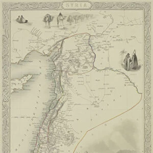
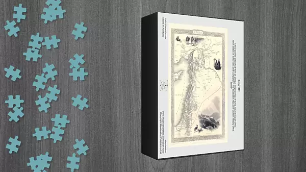
Jigsaw Puzzle : Syria 1851


![]()
Jigsaw Puzzles from MapSeeker
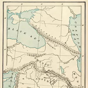
Syria 1851
A fine facimile artworked from an antique original map of Syria, issued as part of the 1851 edition of John Tallis and Companys " The Illustrated Atlas and Modern History of the World"
Welcome to the Mapseeker Image library and enter an historic gateway to one of the largest on-line collections of Historic Maps, Nostalgic Views, Vista's and Panorama's from a World gone by.
Media ID 20347350
© Mapseeker Publishing Ltd
John Tallis John Tallis Map Tallis Map Syria
Jigsaw Puzzle (1000 Pieces)
Discover the rich history of Syria with our captivating jigsaw puzzle from Media Storehouse. Featuring an intricately detailed facsimile of the 1851 John Tallis and John Rapkin map, "Syria 1851" is a journey back in time. This beautiful puzzle, inspired by the original map from The Illustrated Atlas and Modern History of the World, invites you to piece together a piece of history. Explore the intricate borders, geographical features, and historical landmarks of Syria during this fascinating era. A perfect activity for history enthusiasts, puzzle lovers, or anyone seeking a challenging and rewarding pastime.
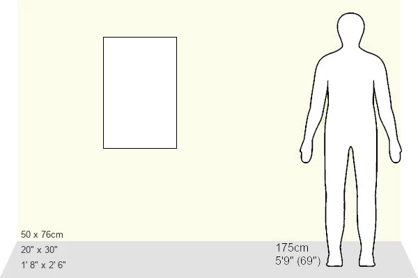
1000 piece puzzles are custom made in Australia and hand-finished on 100% recycled 1.6mm thick laminated puzzle boards. There is a level of repetition in jigsaw shapes with each matching piece away from its pair. The completed puzzle measures 76x50cm and is delivered packaged in an attractive presentation box specially designed to fit most mail slots with a unique magnetic lid
Jigsaw Puzzles are an ideal gift for any occasion
Estimated Product Size is 50.2cm x 76cm (19.8" x 29.9")
These are individually made so all sizes are approximate
Artwork printed orientated as per the preview above, with landscape (horizontal) or portrait (vertical) orientation to match the source image.
FEATURES IN THESE COLLECTIONS
> Arts
> Artists
> S
> Syrian Syrian
> Arts
> Artists
> T
> John Tallis
> Asia
> Syria
> Related Images
> Maps and Charts
> Related Images
> Maps and Charts
> World
> MapSeeker
> Maps of Asia and Middle East
> Maps of the Middle East and East Indies
EDITORS COMMENTS
This print showcases a remarkable piece of history - a fine facsimile artworked from an antique original map of Syria, dating back to 1851. This exquisite map was originally issued as part of the renowned 1851 edition of John Tallis and Company's "The Illustrated Atlas and Modern History of the World". With intricate details and stunning craftsmanship, this old map provides a glimpse into the geographical landscape and historical significance of Syria during that era. Every line, contour, and label on this Syrian map tells a story about the rich heritage and cultural tapestry that has shaped this ancient land. Crafted by esteemed cartographers John Tallis and John Rapkin, this vintage Syrian map is not just an ordinary depiction but rather a work of art in itself. The meticulous attention to detail transports us back in time, allowing us to explore the cities, rivers, mountains, and borders that defined Syria over one hundred years ago. Whether you are an avid collector or simply fascinated by history, this print offers both aesthetic beauty and educational value. It serves as a testament to the enduring legacy left behind by these talented cartographers who dedicated their lives to preserving our world's past through their maps.
MADE IN AUSTRALIA
Safe Shipping with 30 Day Money Back Guarantee
FREE PERSONALISATION*
We are proud to offer a range of customisation features including Personalised Captions, Color Filters and Picture Zoom Tools
SECURE PAYMENTS
We happily accept a wide range of payment options so you can pay for the things you need in the way that is most convenient for you
* Options may vary by product and licensing agreement. Zoomed Pictures can be adjusted in the Cart.