Jigsaw Puzzle > Europe > France > Canton > Landes
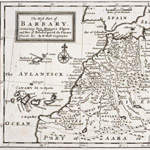
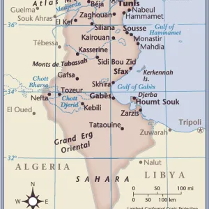
Jigsaw Puzzle : Map / Nw Africa 1719


![]()
Jigsaw Puzzles from Mary Evans Picture Library
Map / Nw Africa 1719
North-west Africa, showing portions of Barbary, land of the Berbers, known to Europeans as barbarians (today Morocco, Tunisia &c)
Mary Evans Picture Library makes available wonderful images created for people to enjoy over the centuries
Media ID 4313297
© Mary Evans Picture Library 2015 - https://copyrighthub.org/s0/hub1/creation/maryevans/MaryEvansPictureID/10032393
1719 Barbarians Barbary Berbers Maps Morocco Portions Today Tunisia Europeans
Jigsaw Puzzle (500 Pieces)
Discover the rich history and culture of North-west Africa with our captivating Jigsaw Puzzle from Media Storehouse. Featuring an intricately detailed map titled "Map / Nw Africa 1719" by Rights Managed from Mary Evans Prints Online, this puzzle invites you to explore the lands of the Berbers, also known as the Barbary Coast to Europeans. Piece together the vibrant and intriguing image of this region, which includes present-day Morocco and Tunisia, and immerse yourself in the fascinating history of this part of the world. A perfect activity for history enthusiasts, puzzle lovers, or anyone seeking a challenging and rewarding pastime.
500 piece puzzles are custom made in Australia and hand-finished on 100% recycled 1.6mm thick laminated puzzle boards. There is a level of repetition in jigsaw shapes with each matching piece away from its pair. The completed puzzle measures 40x51cm and is delivered packaged in an attractive presentation box specially designed to fit most mail slots with a unique magnetic lid
Jigsaw Puzzles are an ideal gift for any occasion
Estimated Product Size is 40.3cm x 50.7cm (15.9" x 20")
These are individually made so all sizes are approximate
Artwork printed orientated as per the preview above, with landscape (horizontal) or portrait (vertical) orientation to match the source image.
FEATURES IN THESE COLLECTIONS
> Africa
> Morocco
> Related Images
> Africa
> Related Images
> Africa
> Tunisia
> Related Images
> Europe
> France
> Canton
> Landes
> Europe
> Related Images
> Maps and Charts
> Early Maps
> Maps and Charts
> Related Images
EDITORS COMMENTS
This stunning print of a map from 1719 showcases the historical region of North-west Africa, known to Europeans as Barbary. The land of the Berbers, who were often labeled as barbarians by outsiders, is depicted in intricate detail on this piece. Today, these territories correspond to modern-day Morocco and Tunisia.
The map provides a fascinating glimpse into the past, offering insights into the geographical boundaries and political landscape of the region during that time period. It serves as a valuable historical artifact that sheds light on how Europeans perceived and interacted with North-west Africa centuries ago.
The intricate design and rich colors of this map make it a visually captivating piece that would be a striking addition to any collection or display. Whether you are a history buff, geography enthusiast, or simply appreciate fine artistry, this print is sure to spark curiosity and conversation.
Explore the nuances of North-west Africa's history through this meticulously crafted map from 1719. Gain a deeper understanding of the interactions between different cultures and civilizations in this region while admiring the beauty and complexity of cartography from centuries past.
MADE IN AUSTRALIA
Safe Shipping with 30 Day Money Back Guarantee
FREE PERSONALISATION*
We are proud to offer a range of customisation features including Personalised Captions, Color Filters and Picture Zoom Tools
SECURE PAYMENTS
We happily accept a wide range of payment options so you can pay for the things you need in the way that is most convenient for you
* Options may vary by product and licensing agreement. Zoomed Pictures can be adjusted in the Cart.