Jigsaw Puzzle > Europe > United Kingdom > England > London > Sights > Regents Park
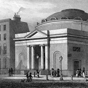
Jigsaw Puzzle : Regents Park Plan C1830


![]()
Jigsaw Puzzles from Mary Evans Picture Library
Regents Park Plan C1830
A plan of Regents Park including Regents Canal and Marylebone Church Date: c1830
Mary Evans Picture Library makes available wonderful images created for people to enjoy over the centuries
Media ID 607269
© Mary Evans Picture Library 2015 - https://copyrighthub.org/s0/hub1/creation/maryevans/MaryEvansPictureID/10058598
C 1830 Canal Including Marylebone Plan Regent
Jigsaw Puzzle (500 Pieces)
Discover the captivating history of Regent's Park with our intricately detailed jigsaw puzzle from Media Storehouse, featuring the "Regents Park Plan C1830" image from Mary Evans Picture Library. This stunning puzzle, brought to you from Mary Evans Prints Online, transports you back in time to the early 19th century, showcasing the grand design of Regent's Park with its iconic Regent's Canal and the beautiful Marylebone Church. Engage in a delightful and educational pastime as you piece together this captivating puzzle, perfect for puzzle enthusiasts and history buffs alike. Experience the joy of bringing the past to life, one piece at a time.
500 piece puzzles are custom made in Australia and hand-finished on 100% recycled 1.6mm thick laminated puzzle boards. There is a level of repetition in jigsaw shapes with each matching piece away from its pair. The completed puzzle measures 40x51cm and is delivered packaged in an attractive presentation box specially designed to fit most mail slots with a unique magnetic lid
Jigsaw Puzzles are an ideal gift for any occasion
Estimated Product Size is 50.7cm x 40.3cm (20" x 15.9")
These are individually made so all sizes are approximate
Artwork printed orientated as per the preview above, with landscape (horizontal) or portrait (vertical) orientation to match the source image.
FEATURES IN THESE COLLECTIONS
> Aerial Photography
> Related Images
> Europe
> United Kingdom
> England
> London
> Sights
> Regents Park
> Maps and Charts
> Early Maps
> Maps and Charts
> Related Images
EDITORS COMMENTS
This stunning aerial view captures the intricate layout of Regents Park in the early 19th century, showcasing its elegant design and lush greenery. The detailed plan includes not only the park itself but also highlights key landmarks such as Regents Canal and Marylebone Church, providing a fascinating glimpse into London's history.
The carefully drawn map offers a unique perspective on this iconic location, allowing viewers to appreciate the meticulous planning that went into creating one of London's most beloved parks. From the winding paths to the serene waterways, every detail is captured with precision and artistry.
As we gaze upon this historical document, we are transported back in time to a bustling cityscape where horse-drawn carriages traversed cobbled streets and grand buildings dotted the skyline. The inclusion of Marylebone Church adds a sense of reverence to the scene, reminding us of the rich cultural heritage that defines this vibrant neighborhood.
Whether you're a history buff or simply appreciate beautiful artwork, this print from Mary Evans Picture Library is sure to captivate your imagination. It serves as a reminder of London's enduring charm and timeless beauty, inviting us to explore its past while marveling at its present-day splendor.
MADE IN AUSTRALIA
Safe Shipping with 30 Day Money Back Guarantee
FREE PERSONALISATION*
We are proud to offer a range of customisation features including Personalised Captions, Color Filters and Picture Zoom Tools
SECURE PAYMENTS
We happily accept a wide range of payment options so you can pay for the things you need in the way that is most convenient for you
* Options may vary by product and licensing agreement. Zoomed Pictures can be adjusted in the Cart.