Metal Print > Europe > United Kingdom > England > London > Sights > Regents Park
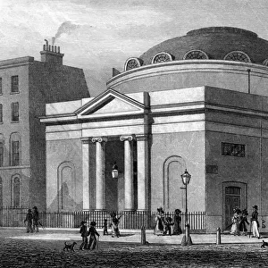
Metal Print : Regents Park Plan C1830


![]()
Metal Prints from Mary Evans Picture Library
Regents Park Plan C1830
A plan of Regents Park including Regents Canal and Marylebone Church Date: c1830
Mary Evans Picture Library makes available wonderful images created for people to enjoy over the centuries
Media ID 607269
© Mary Evans Picture Library 2015 - https://copyrighthub.org/s0/hub1/creation/maryevans/MaryEvansPictureID/10058598
C 1830 Canal Including Marylebone Plan Regent
10"x8" (25x20cm) Table Top Metal Print
Bring the historic charm of Regents Park into your home with our stunning Metal Prints from Media Storehouse. This exquisite piece features an antique plan of Regents Park, as seen in the Mary Evans Picture Library from Mary Evans Prints Online. Dating back to c1830, this detailed map showcases the Regents Canal and the beautiful Marylebone Church. Our high-quality Metal Prints are not just a print, they are a work of art. The vibrant colors and exceptional clarity are brought to life by the unique process that infuses dyes directly into the metal, resulting in a long-lasting, waterproof, and UV-resistant piece. Add a touch of history and elegance to any room with this captivating Regents Park Metal Print.
Table Top Metal Prints feature rounded corners and an easel back for easy display. Available in two sizes, 18x13cm (7x5) or 25x20cm (10x8). Lightweight and vibrant, they are perfect for displaying artwork and are guaranteed to add style to any desk or table top. The unique material is fade, moisture, chemical and scratch resistant to help ensure this art lasts a lifetime.
Made with durable metal and luxurious printing techniques, metal prints bring images to life and add a modern touch to any space
Estimated Product Size is 25.4cm x 20.3cm (10" x 8")
These are individually made so all sizes are approximate
Artwork printed orientated as per the preview above, with landscape (horizontal) or portrait (vertical) orientation to match the source image.
FEATURES IN THESE COLLECTIONS
> Aerial Photography
> Related Images
> Europe
> United Kingdom
> England
> London
> Sights
> Regents Park
> Maps and Charts
> Early Maps
> Maps and Charts
> Related Images
EDITORS COMMENTS
This stunning aerial view captures the intricate layout of Regents Park in the early 19th century, showcasing its elegant design and lush greenery. The detailed plan includes not only the park itself but also highlights key landmarks such as Regents Canal and Marylebone Church, providing a fascinating glimpse into London's history.
The carefully drawn map offers a unique perspective on this iconic location, allowing viewers to appreciate the meticulous planning that went into creating one of London's most beloved parks. From the winding paths to the serene waterways, every detail is captured with precision and artistry.
As we gaze upon this historical document, we are transported back in time to a bustling cityscape where horse-drawn carriages traversed cobbled streets and grand buildings dotted the skyline. The inclusion of Marylebone Church adds a sense of reverence to the scene, reminding us of the rich cultural heritage that defines this vibrant neighborhood.
Whether you're a history buff or simply appreciate beautiful artwork, this print from Mary Evans Picture Library is sure to captivate your imagination. It serves as a reminder of London's enduring charm and timeless beauty, inviting us to explore its past while marveling at its present-day splendor.
MADE IN AUSTRALIA
Safe Shipping with 30 Day Money Back Guarantee
FREE PERSONALISATION*
We are proud to offer a range of customisation features including Personalised Captions, Color Filters and Picture Zoom Tools
SECURE PAYMENTS
We happily accept a wide range of payment options so you can pay for the things you need in the way that is most convenient for you
* Options may vary by product and licensing agreement. Zoomed Pictures can be adjusted in the Cart.