Jigsaw Puzzle > Maps and Charts > Americas
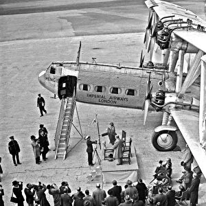
Jigsaw Puzzle : Pan American Airways route map


![]()
Jigsaw Puzzles from Mary Evans Picture Library
Pan American Airways route map
Pan American Airways System global route map of the Flying Clipper Ships (passengers, mail, express).
circa 1938
Mary Evans Picture Library makes available wonderful images created for people to enjoy over the centuries
Media ID 7474817
© Mary Evans Picture Library 2015 - https://copyrighthub.org/s0/hub1/creation/maryevans/MaryEvansPictureID/10610086
1938 Air Line Air Lines Airways Clipper Express Global Lines Logo Mail Maps Passengers Route Routes System Aeronautics
Jigsaw Puzzle (500 Pieces)
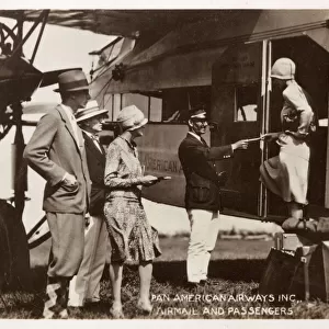
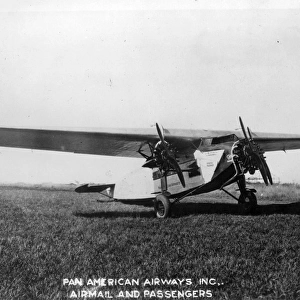
Discover the thrill of piecing together history with our captivating Pan American Airways jigsaw puzzle from the Media Storehouse collection. This intriguing puzzle, featuring a vintage Pan American Airways route map from The Royal Aeronautical Society (National Aerospace Library)/Mary Evans, transports you back to the golden age of aviation. The map showcases the extensive global network of the Flying Clipper Ships, depicting passenger, mail, and express routes from the late 1930s. Immerse yourself in a nostalgic adventure as you bring this iconic piece of aviation history to life, one piece at a time.
500 piece puzzles are custom made in Australia and hand-finished on 100% recycled 1.6mm thick laminated puzzle boards. There is a level of repetition in jigsaw shapes with each matching piece away from its pair. The completed puzzle measures 40x51cm and is delivered packaged in an attractive presentation box specially designed to fit most mail slots with a unique magnetic lid
Jigsaw Puzzles are an ideal gift for any occasion
Estimated Product Size is 50.7cm x 40.3cm (20" x 15.9")
These are individually made so all sizes are approximate
Artwork printed orientated as per the preview above, with landscape (horizontal) or portrait (vertical) orientation to match the source image.
FEATURES IN THESE COLLECTIONS
> Maps and Charts
> Related Images
> Maps and Charts
> World
> Mary Evans Prints Online
> Royal Aeronautical Society
EDITORS COMMENTS
Step into the golden age of aviation with this Pan American Airways System route map from 1938. This vintage aeronautical chart depicts the extensive global network of Pan Am's Flying Clipper Ships, connecting the Americas with Europe and beyond. The iconic red, white, and blue Pan Am logo proudly graces the top of the map, symbolizing the American spirit of innovation and exploration that drove the growth of this pioneering airline. The intricate web of lines on the map represents the various routes served by Pan Am's fleet of Clipper ships, which revolutionized air travel in the 1930s. Passengers and mail could now traverse vast distances in record time, bridging continents and bringing the world closer together. The map also highlights the strategic importance of Pan Am's transatlantic routes, which connected North and South America with Europe, making international travel more accessible and convenient than ever before. As you explore the intricate details of this map, you can almost hear the roar of the Clipper engines and feel the excitement of embarking on a journey to far-off lands. This is a fascinating glimpse into the history of aviation and the role that Pan American Airways played in shaping the way we travel today. A true collector's item for aviation enthusiasts and history buffs alike, this vintage map is a must-have for any home or office.
MADE IN AUSTRALIA
Safe Shipping with 30 Day Money Back Guarantee
FREE PERSONALISATION*
We are proud to offer a range of customisation features including Personalised Captions, Color Filters and Picture Zoom Tools
SECURE PAYMENTS
We happily accept a wide range of payment options so you can pay for the things you need in the way that is most convenient for you
* Options may vary by product and licensing agreement. Zoomed Pictures can be adjusted in the Cart.