Jigsaw Puzzle > Africa > Angola > Maps
Jigsaw Puzzle : EXPL2A-00366


![]()
Jigsaw Puzzles from North Wind
EXPL2A-00366
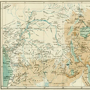
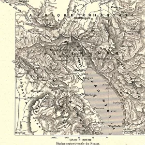
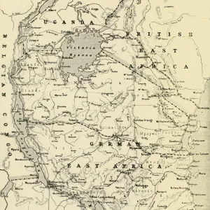
Map of equatorial Africa as known in the 1870s.
Printed color lithograph, 19th century
North Wind Picture Archives brings history to life with stock images and hand-colored illustrations
Media ID 5876012
© North Wind Picture Archives
1870s Africa African Cartography Colonial Colony Congo Discover East Africa Exploration Explore Nile Nile River West Africa Angola Bantu Central Africa Congo River Equator Head Waters Malawi Mozambique Northern Rhodesia Nyasaland Rwanda Tanganyika Uganda Zambia Zanzibar
Jigsaw Puzzle (500 Pieces)
Discover the mysteries of the past with our captivating Explorer Series jigsaw puzzle from Media Storehouse. Featuring the intriguing "EXPL2A-00366" image from North Wind Picture Archives, this vintage map of Equatorial Africa as known in the 1870s is a fascinating journey back in time. With vibrant colors and intricate details, this 19th-century printed color lithograph puzzle promises an engaging and educational experience for puzzle enthusiasts of all ages. Get ready to piece together history and uncover the stories hidden within this captivating puzzle.
500 piece puzzles are custom made in Australia and hand-finished on 100% recycled 1.6mm thick laminated puzzle boards. There is a level of repetition in jigsaw shapes with each matching piece away from its pair. The completed puzzle measures 40x51cm and is delivered packaged in an attractive presentation box specially designed to fit most mail slots with a unique magnetic lid
Jigsaw Puzzles are an ideal gift for any occasion
Estimated Product Size is 50.7cm x 40.3cm (20" x 15.9")
These are individually made so all sizes are approximate
Artwork printed orientated as per the preview above, with landscape (horizontal) or portrait (vertical) orientation to match the source image.
FEATURES IN THESE COLLECTIONS
> Africa
> Angola
> Related Images
> Africa
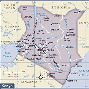
> Kenya
> Related Images
> Africa
> Malawi
> Related Images
> Africa
> Mozambique
> Maps
> Africa
> Mozambique
> Related Images
> Africa
> Related Images
> North Wind Picture Archives
> Africa history
> North Wind Picture Archives
> Maps
EDITORS COMMENTS
This vintage print takes us back to the 1870s, showcasing a beautifully detailed map of equatorial Africa. The vibrant colors and intricate illustrations bring this historic piece to life, offering a glimpse into the continent's geography during that era. From Kenya to Angola, from Zanzibar to Mozambique, this map encompasses various regions and territories that were part of colonial Africa. The Nile River stands out prominently, winding its way through Sudan and Egypt before flowing into the Mediterranean Sea. As we explore further inland, we encounter the vast Congo River and its tributaries snaking through Central Africa. This visual representation allows us to trace the headwaters of these mighty rivers as they traverse through different countries. The map also highlights significant landmarks such as Rwanda, Uganda, Tanganyika (now Tanzania), Nyasaland (now Malawi), Zambia (formerly Northern Rhodesia), and more. It provides valuable insights into African history by depicting colonial boundaries and Bantu ethnic groups scattered across the region. As we gaze upon this artwork, it serves as a reminder of how cartography played an essential role in exploration during the 19th century. It sparks curiosity about what early explorers might have encountered on their journeys across equatorial Africa. This print is not just a historical artifact; it is a testament to human curiosity and our never-ending quest for knowledge about our world's diverse landscapes.
MADE IN AUSTRALIA
Safe Shipping with 30 Day Money Back Guarantee
FREE PERSONALISATION*
We are proud to offer a range of customisation features including Personalised Captions, Color Filters and Picture Zoom Tools
SECURE PAYMENTS
We happily accept a wide range of payment options so you can pay for the things you need in the way that is most convenient for you
* Options may vary by product and licensing agreement. Zoomed Pictures can be adjusted in the Cart.