Jigsaw Puzzle > Europe > United Kingdom > Wales > Maps
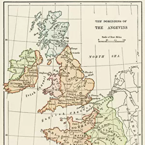
Jigsaw Puzzle : Map of England and France, 1154


![]()
Jigsaw Puzzles from North Wind
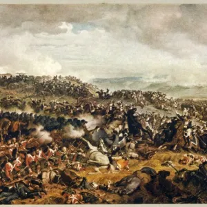
Map of England and France, 1154
England and France at the accession of Henry II, 1154.
Color lithograph reproduction of a 19th-century illustration
North Wind Picture Archives brings history to life with stock images and hand-colored illustrations
Media ID 5879168
© North Wind Picture Archives
100 Years War 1100s 12th Century British Eire England English Europe Family France French Great Britain Ireland Medieval Middle Ages Wales Angevin Anjou Henry Curtmantle Henry Ii King Henry Ii Plantagenet
Jigsaw Puzzle (500 Pieces)
Discover the rich history of Europe with our intricately detailed Media Storehouse Jigsaw Puzzle featuring a captivating Map of England and France from 1154. This beautiful puzzle, drawn from the North Wind Picture Archives, is a color lithograph reproduction of a 19th-century illustration. Piece together this historical puzzle and journey back in time to the accession of Henry II, immersing yourself in the intricacies of Europe's past. A perfect activity for history enthusiasts, families, or anyone seeking a challenging and rewarding puzzle experience.
500 piece puzzles are custom made in Australia and hand-finished on 100% recycled 1.6mm thick laminated puzzle boards. There is a level of repetition in jigsaw shapes with each matching piece away from its pair. The completed puzzle measures 40x51cm and is delivered packaged in an attractive presentation box specially designed to fit most mail slots with a unique magnetic lid
Jigsaw Puzzles are an ideal gift for any occasion
Estimated Product Size is 40.3cm x 50.7cm (15.9" x 20")
These are individually made so all sizes are approximate
Artwork printed orientated as per the preview above, with landscape (horizontal) or portrait (vertical) orientation to match the source image.
FEATURES IN THESE COLLECTIONS
> Arts
> Art Movements
> Medieval Art
> Europe
> Republic of Ireland
> Maps
> Europe
> United Kingdom
> England
> Maps
> Europe
> United Kingdom
> Maps
> Europe
> United Kingdom
> Wales
> Maps
> Europe
> United Kingdom
> Wales
> Posters
> Europe
> United Kingdom
> Wales
> Related Images
> North Wind Picture Archives
> British history
> North Wind Picture Archives
> Maps
EDITORS COMMENTS
This color lithograph reproduction showcases a remarkable illustration of the "Map of England and France, 1154". Transporting us back to the medieval era, this vintage print captures the essence of heritage and tradition. The map depicts England and France at the accession of Henry II in 1154, offering a glimpse into the political landscape of that time. With intricate details and vibrant colors, this artwork beautifully portrays the territories ruled by Henry II's dynasty, known as Plantagenet. From Great Britain to Ireland, Wales to Anjou, it highlights the vast dominions under his reign. This visual representation takes us on a journey through history when English and French influences intertwined during an era marked by significant events. The map not only serves as a historical artifact but also evokes curiosity about Europe in the 12th century. It reminds us of King Henry II himself - often referred to as Henry Curtmantle - who played a crucial role in shaping both English and French history. As we admire this piece of art from North Wind Picture Archives, we are reminded of its significance beyond aesthetics. It symbolizes centuries-old conflicts like the Angevin Empire's struggles against France during events such as the Hundred Years' War. A true testament to our shared past, this illustration invites us to explore one of history's most intriguing periods: The Middle Ages.
MADE IN AUSTRALIA
Safe Shipping with 30 Day Money Back Guarantee
FREE PERSONALISATION*
We are proud to offer a range of customisation features including Personalised Captions, Color Filters and Picture Zoom Tools
SECURE PAYMENTS
We happily accept a wide range of payment options so you can pay for the things you need in the way that is most convenient for you
* Options may vary by product and licensing agreement. Zoomed Pictures can be adjusted in the Cart.