Jigsaw Puzzle > Universal Images Group (UIG) > Art > Painting, Sculpture & Prints > Cartography
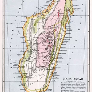
Jigsaw Puzzle : Map of Madagascar by Jacques-Nicolas Bellin, 1766


![]()
Jigsaw Puzzles from Universal Images Group (UIG)
Map of Madagascar by Jacques-Nicolas Bellin, 1766
Cartography, 18th century. Map of Madagascar by Jacques-Nicolas Bellin, 1766
Universal Images Group (UIG) manages distribution for many leading specialist agencies worldwide
Media ID 9572269
© DEA / M. SEEMULLER
18th Century Island Madagascar Western Script Non Urban Scene
Jigsaw Puzzle (1000 Pieces)
Discover the wonders of cartography with Media Storehouse's Jigsaw Puzzle of the historic "Map of Madagascar" by Jacques-Nicolas Bellin, dated 1766. This intricately detailed puzzle features the beautiful and captivating map, originally published by UIG, showcasing the intriguing geography and rich history of Madagascar during the 18th century. Immerse yourself in the past as you piece together this challenging and educational puzzle, perfect for anyone with an interest in history, geography, or puzzle solving. Experience the thrill of discovery as you bring this piece of cartographic history back to life.
1000 piece puzzles are custom made in Australia and hand-finished on 100% recycled 1.6mm thick laminated puzzle boards. There is a level of repetition in jigsaw shapes with each matching piece away from its pair. The completed puzzle measures 76x50cm and is delivered packaged in an attractive presentation box specially designed to fit most mail slots with a unique magnetic lid
Jigsaw Puzzles are an ideal gift for any occasion
Estimated Product Size is 76cm x 50.2cm (29.9" x 19.8")
These are individually made so all sizes are approximate
Artwork printed orientated as per the preview above, with landscape (horizontal) or portrait (vertical) orientation to match the source image.
EDITORS COMMENTS
This print showcases a historical gem - the Map of Madagascar by Jacques-Nicolas Bellin, dating back to 1766. The image transports us to the enchanting world of 18th-century cartography, where meticulous craftsmanship and artistry converged. In this studio shot, we are presented with a full-length view of the map, which beautifully captures the island's intricate landscape. The Map of Madagascar is an exquisite example of physical geography brought to life through Bellin's skilled hand. Its horizontal orientation allows us to immerse ourselves in every detail and contour that defines this remarkable landmass. As we explore its non-urban scene, devoid of any human presence, we can't help but marvel at the past it represents. Bellin's use of Western script adds another layer of intrigue as it guides our eyes across this masterpiece. The careful selection and placement of each element on the map demonstrate his expertise in both illustration and painting. This print from Universal Images Group (UIG) serves as a window into history, inviting us to appreciate not only the beauty but also the significance behind ancient maps like these. It reminds us that cartography was once an art form unto itself – one that allowed people to navigate uncharted territories and expand their understanding of our vast world
MADE IN AUSTRALIA
Safe Shipping with 30 Day Money Back Guarantee
FREE PERSONALISATION*
We are proud to offer a range of customisation features including Personalised Captions, Color Filters and Picture Zoom Tools
SECURE PAYMENTS
We happily accept a wide range of payment options so you can pay for the things you need in the way that is most convenient for you
* Options may vary by product and licensing agreement. Zoomed Pictures can be adjusted in the Cart.