Poster Print > Universal Images Group (UIG) > Art > Painting, Sculpture & Prints > Cartography
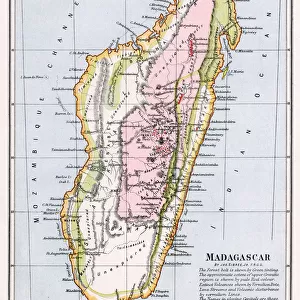
Poster Print : Map of Madagascar by Jacques-Nicolas Bellin, 1766


![]()
Poster Prints from Universal Images Group (UIG)
Map of Madagascar by Jacques-Nicolas Bellin, 1766
Cartography, 18th century. Map of Madagascar by Jacques-Nicolas Bellin, 1766
Universal Images Group (UIG) manages distribution for many leading specialist agencies worldwide
Media ID 9572269
© DEA / M. SEEMULLER
18th Century Island Madagascar Western Script Non Urban Scene
A4 (29.7 x 21cm) Poster Print
Discover the rich history of cartography with our exquisite selection of antique poster prints from Universal Images Group (UIG). This particular piece showcases a stunning Map of Madagascar, created by Jacques-Nicolas Bellin in 1766. Bellin, a renowned French cartographer, meticulously crafted this map during the 18th century, providing an intriguing glimpse into the geographical knowledge of that era. Add an air of sophistication and historical charm to your home or office with this beautiful, museum-quality poster print. A must-have for cartography enthusiasts, historians, or anyone who appreciates the art of mapmaking.
Premium quality poster prints are printed on luxurious semi-gloss satin 270 gsm paper. Our meticulously crafted poster prints offer an affordable option for decorating any space, making them ideal for living rooms, bedrooms, offices and beyond. To ensure your poster arrives in good condition, we roll and send them in strong mailing tubes.
Poster prints are budget friendly enlarged prints in standard poster paper sizes (A0, A1, A2, A3 etc). Whilst poster paper is sometimes thinner and less durable than our other paper types, they are still ok for framing and should last many years. Our Archival Quality Photo Prints and Fine Art Paper Prints are printed on higher quality paper and the choice of which largely depends on your budget.
Estimated Image Size (if not cropped) is 30.3cm x 20.8cm (11.9" x 8.2")
Estimated Product Size is 30.3cm x 21.6cm (11.9" x 8.5")
These are individually made so all sizes are approximate
Artwork printed orientated as per the preview above, with landscape (horizontal) orientation to match the source image.
EDITORS COMMENTS
This print showcases a historical gem - the Map of Madagascar by Jacques-Nicolas Bellin, dating back to 1766. The image transports us to the enchanting world of 18th-century cartography, where meticulous craftsmanship and artistry converged. In this studio shot, we are presented with a full-length view of the map, which beautifully captures the island's intricate landscape. The Map of Madagascar is an exquisite example of physical geography brought to life through Bellin's skilled hand. Its horizontal orientation allows us to immerse ourselves in every detail and contour that defines this remarkable landmass. As we explore its non-urban scene, devoid of any human presence, we can't help but marvel at the past it represents. Bellin's use of Western script adds another layer of intrigue as it guides our eyes across this masterpiece. The careful selection and placement of each element on the map demonstrate his expertise in both illustration and painting. This print from Universal Images Group (UIG) serves as a window into history, inviting us to appreciate not only the beauty but also the significance behind ancient maps like these. It reminds us that cartography was once an art form unto itself – one that allowed people to navigate uncharted territories and expand their understanding of our vast world
MADE IN AUSTRALIA
Safe Shipping with 30 Day Money Back Guarantee
FREE PERSONALISATION*
We are proud to offer a range of customisation features including Personalised Captions, Color Filters and Picture Zoom Tools
SECURE PAYMENTS
We happily accept a wide range of payment options so you can pay for the things you need in the way that is most convenient for you
* Options may vary by product and licensing agreement. Zoomed Pictures can be adjusted in the Cart.