Jigsaw Puzzle > Europe > United Kingdom > England > Sussex > Edburton
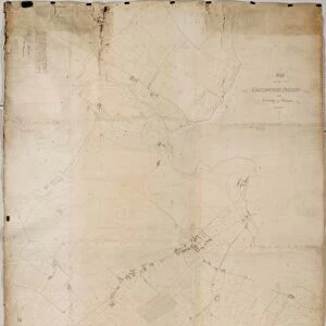
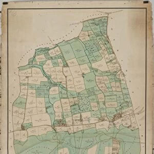
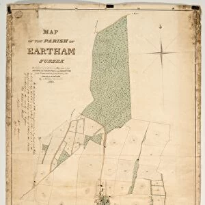
Jigsaw Puzzle : Edburton tithe map, 1842


![]()
Jigsaw Puzzles from West Sussex County Council
Edburton tithe map, 1842
By E. & G. N. Driver, Parliament Street, London. 13.3 in. to 1m. 49 × 28
Tithe Award Map Collection
West Sussex Record Office Ref No: TD/W168
West Sussex County Council Record Office contains a fascinating history of the county of West Sussex, England
Media ID 10716321
© West Sussex County Council - All Rights Reserved
1840s 19th Century Historical Mapping South Of England
Jigsaw Puzzle (1000 Pieces)
Discover the rich history of West Sussex with our captivating Edburton Tithe Map, 1842 jigsaw puzzle from Media Storehouse. This intricately detailed puzzle, based on the original map held at the West Sussex Record Office, invites you on a journey back in time. Once completed, marvel at the intricate depiction of land ownership and property boundaries from over 175 years ago. Immerse yourself in the history and beauty of Edburton with this engaging and educational puzzle.
1000 piece puzzles are custom made in Australia and hand-finished on 100% recycled 1.6mm thick laminated puzzle boards. There is a level of repetition in jigsaw shapes with each matching piece away from its pair. The completed puzzle measures 76x50cm and is delivered packaged in an attractive presentation box specially designed to fit most mail slots with a unique magnetic lid
Jigsaw Puzzles are an ideal gift for any occasion
Estimated Product Size is 50.2cm x 76cm (19.8" x 29.9")
These are individually made so all sizes are approximate
Artwork printed orientated as per the preview above, with landscape (horizontal) or portrait (vertical) orientation to match the source image.
FEATURES IN THESE COLLECTIONS
> Europe
> United Kingdom
> England
> Ely
> Europe
> United Kingdom
> England
> Maps
> Europe
> United Kingdom
> England
> Sussex
> Edburton
> Europe
> United Kingdom
> England
> Sussex
> Related Images
> Europe
> United Kingdom
> England
> Sussex
> South Street
> Europe
> United Kingdom
> England
> West Sussex
> Related Images
> Maps and Charts
> Early Maps
> Maps and Charts
> Related Images
> West Sussex County Council
> West Sussex Record Office
> Tithe Award Maps, 1808-1859
EDITORS COMMENTS
This print showcases the Edburton tithe map from 1842, a remarkable piece of historical mapping that offers a glimpse into the past. Created by E. & G. N. Driver, Parliament Street, London, this meticulously detailed map measures at an impressive scale of 13.3 inches to 1 meter and spans an area of 49 acres by 28 acres. The Edburton tithe map is part of the esteemed Tithe Award Map Collection housed at the West Sussex Record Office (Ref No: TD/W168). This collection holds immense value for researchers and history enthusiasts alike as it provides invaluable insights into land ownership and usage during the mid-19th century in southern England. As we delve into this visual treasure trove, we are transported back in time to witness how landscapes were divided and utilized centuries ago. The intricate details captured on this map allow us to explore every nook and cranny of Edburton with great precision. It is important to note that this print should not be used for commercial purposes but rather cherished as a valuable historical artifact preserved by West Sussex County Council. With its rich history embedded within each stroke of ink, this image serves as a testament to our collective heritage and invites us to appreciate the beauty found in both nature's landscape and human ingenuity throughout time.
MADE IN AUSTRALIA
Safe Shipping with 30 Day Money Back Guarantee
FREE PERSONALISATION*
We are proud to offer a range of customisation features including Personalised Captions, Color Filters and Picture Zoom Tools
SECURE PAYMENTS
We happily accept a wide range of payment options so you can pay for the things you need in the way that is most convenient for you
* Options may vary by product and licensing agreement. Zoomed Pictures can be adjusted in the Cart.

![Chichester St. Peter the Great [Subdeanery] tithe map, 1846-1847](/sq/479/chichester-st-peter-great-subdeanery-tithe-10701869.jpg.webp)