Home > Asia > Palestine > Maps
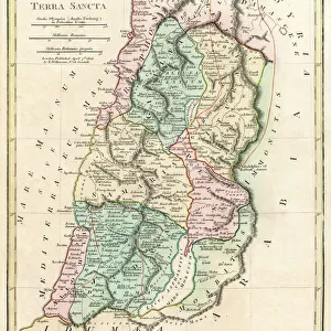
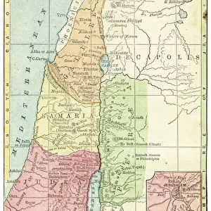
Israel, Palestine, Jerusalem Map Gotha, Justus Perthes, 1875, Atlas

![]()
Wall Art and Photo Gifts from Liszt Collection
Israel, Palestine, Jerusalem Map Gotha, Justus Perthes, 1875, Atlas
Israel, Palestine, Jerusalem Map Gotha, Justus Perthes, 1875, Atlas. Perthes, Johan Georg Justus 1749 aa 1816, German publisher, was born in Rudolstadt in 1749. In 1785 he founded at Gotha the business which bears his name, Justus Perthes. In this he was joined in 1814 by his son Wilhelm, 1793 aa 1853. He laid the foundation of the Geographical Branch of the business, for which it is chiefly famous, by publishing the and-Atlas (1817-1823) of Adolf Stieler (1775-1836). Wilhelm Perthes engaged the collaboration of the most eminent German geographers of the time, including Heinrich Berghaus, Christian Gottlieb Reichard, Karl Spruler and Emil von Sydow. The business passed to his son Bernard Wilhelm Perthes (1821-1857). In 1863 the firm first issued the Almanach de Gotha, a statistical, Historical and genealogical Annual (in French) of the various countries of the world
Liszt Collection of nineteenth-century engravings and images to browse and enjoy
Media ID 12958935
© Quint Lox Limited
1793 1853 1875 Allemagne Book Of Maps Bundesrepublik Deutschland D Allemagne Deutschland Erfurt German Publisher Gotha Justus Perthes Liszt Collection Perthes Republica Federal De Alemania Thuringia Atlas
FEATURES IN THESE COLLECTIONS
> Asia
> Palestine
> Jerusalem
> Liszt Collection
> Engravings
> Maps and Charts
> Early Maps
> Maps and Charts
> World
EDITORS COMMENTS
This vintage print showcases the Israel, Palestine, Jerusalem Map Gotha from Justus Perthes' 1875 Atlas. Justus Perthes was a renowned German publisher who established his business in Gotha in 1785. His son Wilhelm joined him in 1814 and together they laid the foundation of the Geographical Branch of their business by publishing Adolf Stieler's famous And-Atlas (1817-1823). This particular map is a testament to their collaboration with eminent German geographers such as Heinrich Berghaus, Christian Gottlieb Reichard, Karl Spruler, and Emil von Sydow. The Liszt Collection has preserved this historical artifact that offers insight into the geography and boundaries of Israel, Palestine, and Jerusalem during the late 19th century. The intricately engraved image captures not only geographical details but also exemplifies an illustrative technique prevalent during that era. With its retro-styled appeal and Victorian charm, this print transports us back in time to explore history through art. It serves as a reminder of how maps have played a crucial role in understanding our world throughout centuries.
MADE IN AUSTRALIA
Safe Shipping with 30 Day Money Back Guarantee
FREE PERSONALISATION*
We are proud to offer a range of customisation features including Personalised Captions, Color Filters and Picture Zoom Tools
SECURE PAYMENTS
We happily accept a wide range of payment options so you can pay for the things you need in the way that is most convenient for you
* Options may vary by product and licensing agreement. Zoomed Pictures can be adjusted in the Cart.