Home > Europe > Germany > Maps
Map North America Gotha, Justus Perthes, 1872, Atlas

![]()
Wall Art and Photo Gifts from Liszt Collection
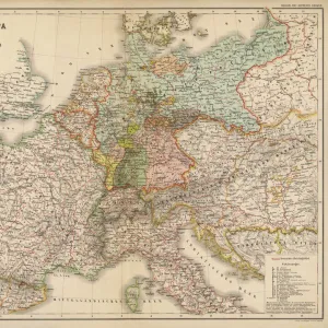
Map North America Gotha, Justus Perthes, 1872, Atlas
Map North America Gotha, Justus Perthes, 1872, Atlas. Perthes, Johan Georg Justus 1749 aa 1816, German publisher, was born in Rudolstadt in 1749. In 1785 he founded at Gotha the business which bears his name, Justus Perthes. In this he was joined in 1814 by his son Wilhelm, 1793 aa 1853. He laid the foundation of the Geographical Branch of the business, for which it is chiefly famous, by publishing the and-Atlas (1817-1823) of Adolf Stieler (1775-1836). Wilhelm Perthes engaged the collaboration of the most eminent German geographers of the time, including Heinrich Berghaus, Christian Gottlieb Reichard, Karl Spruler and Emil von Sydow. The business passed to his son Bernard Wilhelm Perthes (1821-1857). In 1863 the firm first issued the Almanach de Gotha, a statistical, Historical and genealogical Annual (in French) of the various countries of the world
Liszt Collection of nineteenth-century engravings and images to browse and enjoy
Media ID 12958905
© Quint Lox Limited
1872 Allemagne Book Of Maps Bundesrepublik Deutschland D Allemagne D,allemagne Deutschland Erfurt German Publisher Gotha Johan Georg Justus 1749 – 1816 Johan Georg Justus 17491816 Justus Perthes Republica Federal De Alemania Thuringia Atlas
FEATURES IN THESE COLLECTIONS
> Liszt Collection
> Engravings
> Maps and Charts
> Early Maps
> Maps and Charts
> World
> North America
> Related Images
EDITORS COMMENTS
This vintage print showcases the "Map North America Gotha" from Justus Perthes' 1872 Atlas. Justus Perthes, a renowned German publisher, established his business in Gotha in 1785 and later expanded it with the help of his son Wilhelm. The Geographical Branch of their enterprise gained fame by publishing Adolf Stieler's And-Atlas between 1817 and 1823. Collaborating with esteemed German geographers like Heinrich Berghaus and Christian Gottlieb Reichard, Wilhelm Perthes solidified the foundation of this branch. The depicted map represents North America during that era, providing historical insights into its geographical features and boundaries. Its intricate engravings reflect the illustrative techniques prevalent during Victorian times. This image takes us back to a bygone era when cartography was both an art form and a scientific endeavor. Hailing from Rudolstadt, Germany, Justus Perthes' legacy continued through generations until Bernard Wilhelm Perthes took over the business in 1857. In addition to their maps, they also published the Almanach de Gotha starting in 1863—a comprehensive annual publication encompassing statistics, history, and genealogy of various countries worldwide. This particular print is part of Liszt Collection's archives—an extensive collection preserving historical images for educational purposes. It serves as a testament to Justus Perthes' significant contributions to cartography while offering viewers a glimpse into North America's past through this beautifully crafted map.
MADE IN AUSTRALIA
Safe Shipping with 30 Day Money Back Guarantee
FREE PERSONALISATION*
We are proud to offer a range of customisation features including Personalised Captions, Color Filters and Picture Zoom Tools
SECURE PAYMENTS
We happily accept a wide range of payment options so you can pay for the things you need in the way that is most convenient for you
* Options may vary by product and licensing agreement. Zoomed Pictures can be adjusted in the Cart.