Home > Arts > Artists > K > Johannes van Keulen
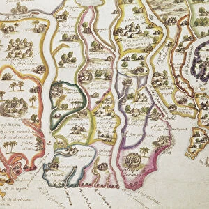
Sea chart of the coast of Gambia and part of the coast of Senegal, Guinea and Sierra

![]()
Wall Art and Photo Gifts from Liszt Collection
Sea chart of the coast of Gambia and part of the coast of Senegal, Guinea and Sierra
Sea chart of the coast of Gambia and part of the coast of Senegal, Guinea and Sierra Leone, print maker: Jan Luyken, Johannes van Keulen I, unknown, 1683 - 1799
Liszt Collection of nineteenth-century engravings and images to browse and enjoy
Media ID 12716075
© Quint Lox Limited
1683 1799 Address Apes Black Man Coast Compass Compasses Feather Headdress French Miles Gambia Guinea Headdress Jan Luyken Johannes Van Keulen Leone Monkey Monkeys Monsters North Roses Runs Sea Chart Senegal Serpent Sierra Leone Snake Snakes Buffaloes Chart Hoses Sierra
FEATURES IN THESE COLLECTIONS
> Africa
> The Gambia
> Maps
> Africa
> Sierra Leone
> Maps
> Arts
> Artists
> K
> Johannes van Keulen
> Arts
> Artists
> L
> Jan Luyken
> Maps and Charts
> World
EDITORS COMMENTS
This print showcases a remarkable sea chart of the coast of Gambia and parts of Senegal, Guinea, and Sierra Leone. Created by renowned printmakers Jan Luyken and Johannes van Keulen I between 1683 and 1799, this map is a true testament to their mastery in cartography. As we delve into the intricacies of this historical piece, our eyes are immediately drawn to the vivid depictions that adorn its surface. Snakes slithering through waves, monstrous creatures lurking beneath the depths, monkeys swinging from branch to branch - all come together to create an enchanting scene that captures both imagination and curiosity. The presence of a black man wearing a feather headdress adds cultural significance to this artwork. With an ax in hand, he stands amidst cut snakes while monkey runs nearby. This portrayal hints at the rich diversity found along these coastal regions during that era. Compasses and compass roses meticulously placed on the chart guide us towards cardinal directions as we explore every inch of this geographical marvel. The inclusion of French miles further emphasizes its historical context. In Quint Lox's skillful capture, one can appreciate not only the artistry behind this sea chart but also its invaluable contribution to our understanding of world geography centuries ago. It serves as a reminder that even in today's digital age, there is still immense beauty in tangible representations like maps – windows into our past adventures across land and sea.
MADE IN AUSTRALIA
Safe Shipping with 30 Day Money Back Guarantee
FREE PERSONALISATION*
We are proud to offer a range of customisation features including Personalised Captions, Color Filters and Picture Zoom Tools
SECURE PAYMENTS
We happily accept a wide range of payment options so you can pay for the things you need in the way that is most convenient for you
* Options may vary by product and licensing agreement. Zoomed Pictures can be adjusted in the Cart.