Home > Europe > United Kingdom > England > London > Boroughs > Croydon
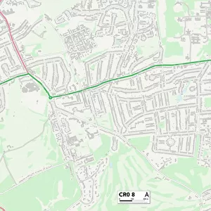
Croydon CR5 3 Map

![]()
Wall Art and Photo Gifts from Map Marketing
Croydon CR5 3 Map
Postcode Sector Map of Croydon CR5 3
Media ID 19968057
Alexander Road Bell Crescent Bennett Close Bridge Way Brighton Road Broad Walk Castle Road Chelwood Close Church Lane Coniston Road Croydon Dacre Close Dene Close Dickens Drive Dobson Close Elmore Road Farm Close Grange Close Green Lane Hazel Way Hazelwood Lane High Oaks High Road Holly Lane Jenner Close Johnson Drive Keats Way Lavender Close Lime Tree Avenue Linden Avenue Lower Park Road Lyndhurst Road Maple Way Middlefield Close Nutfield Road Parkside Gardens Petworth Close Rectory Lane Rectory Road Reid Close Rowan Grove Salter Close Sandown Road Sherwood Road St Andrews Road St Margarets Road Star Lane Station Approach Vincent Road Walpole Avenue White Hill Winifred Road Woodfield Close Woodlands Grove Woodstock Road Yew Tree Close Chipstead Woodmansterne
FEATURES IN THESE COLLECTIONS
> Map Marketing
> Postcode Sector Maps
> CR - Croydon
> Animals
> Mammals
> Cricetidae
> Brown Cane Mouse
> Animals
> Mammals
> Muridae
> Water Mouse
> Arts
> Artists
> B
> Charles Bell
> Arts
> Artists
> C
> James Charles
> Arts
> Artists
> D
> Charles Dickens
> Arts
> Artists
> G
> Charles Green
> Arts
> Artists
> T
> Charles Turner
> Arts
> Artists
> W
> Charles White
> Europe
> United Kingdom
> England
> London
> Boroughs
> Croydon
MADE IN AUSTRALIA
Safe Shipping with 30 Day Money Back Guarantee
FREE PERSONALISATION*
We are proud to offer a range of customisation features including Personalised Captions, Color Filters and Picture Zoom Tools
SECURE PAYMENTS
We happily accept a wide range of payment options so you can pay for the things you need in the way that is most convenient for you
* Options may vary by product and licensing agreement. Zoomed Pictures can be adjusted in the Cart.