Home > Arts > Artists > F > Alfred Fredericks
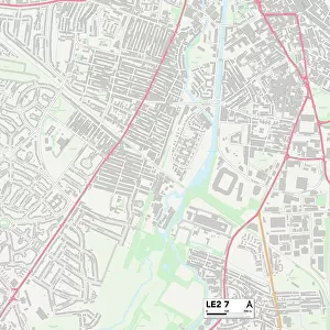
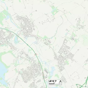
Leicester LE7 3 Map

![]()
Wall Art and Photo Gifts from Map Marketing
Leicester LE7 3 Map
Postcode Sector Map of Leicester LE7 3
Media ID 19973410
Avenue Close Avenue Road Beechwood Avenue Blackfriars Road Bluebell Close Brookside Broomfield Chapel Close Chestnut Close Chestnut Way Coppice Lane Cornflower Close Curzon Close Daisy Close Farriers Way Fox Hollow Foxglove Close Glebe Road Hall Farm Close Harebell Close Hertford Close King Street Kings Lane Leicester Link Road Magdalen Close Main Street Melton Road Mere Lane New Street Nursery Close Park Lane Primrose Way Queen Street Saddlers Close School Lane Somerville Close Spring Court Teasel Close The Banks The Burrows The Chase The Meadows The Ridings The Warren Thorpe Lane Vicarage Lane Wadham Close Watergate Wetherby Close William Close Drovers Road
FEATURES IN THESE COLLECTIONS
> Map Marketing
> Postcode Sector Maps
> LE - Leicester
> Animals
> Mammals
> Muridae
> Ling
> Animals
> Mammals
> Squirrel
> Arts
> Artists
> D
> Alfred
> Related Images
> Arts
> Artists
> E
> Alfred East
> Arts
> Artists
> F
> Alfred Fredericks
> Arts
> Portraits
> Pop art gallery
> Street art portraits
> Maps and Charts
> Related Images
> Oceania
> New Zealand
> Maps
> Oceania
> New Zealand
> Related Images
MADE IN AUSTRALIA
Safe Shipping with 30 Day Money Back Guarantee
FREE PERSONALISATION*
We are proud to offer a range of customisation features including Personalised Captions, Color Filters and Picture Zoom Tools
SECURE PAYMENTS
We happily accept a wide range of payment options so you can pay for the things you need in the way that is most convenient for you
* Options may vary by product and licensing agreement. Zoomed Pictures can be adjusted in the Cart.